


Pondicherry, also known as Puducherry, is a union territory of India. Unlike many other parts of India, Pondicherry has a mostly flat landscape with no hills or forests. Nestled on the southeastern coast of India along the Bay of Bengal, Pondicherry’s terrain offers a blend of coastal beauty, flat plains, river systems, and unique ecological habitats. The average elevation is at sea level, and there are several sea inlets, known as “backwaters.” The main soil types found here are red ferrallitic, black clay, and coastal alluvial. To understand the unique charm of Pondicherry, we need to explore its physical features, from its sandy beaches to its serene backwaters.
It consists of four small unconnected districts, Puducherry, Karaikal, Mahe, and Yanam. Each of these districts has unique physical features and contributes to the region’s biodiversity.
Geographical Area
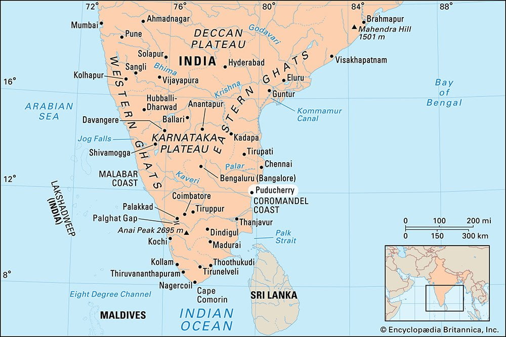
The entire Union Territory of Puducherry, which includes Pondicherry as the capital city, covers a total area of approximately 492 square kilometers (186 square miles). Four disconnected districts spread across different parts of South India make up the union territory of Puducherry.
- Puducherry district: Covers 293 km² (113 sq mi) and is situated along the southeastern Coromandel Coast, surrounded by Tamil Nadu state. A canal divides the city of Puducherry into two parts, with main streets leading to the open roadstead offshore.
- Karaikal district: Spreads over 161 km² (62 sq mi) and lies in the fertile Kaveri River delta, an important rice-producing area of India. The area is completely surrounded by the Tanjavur district.
- Yanam district: Occupies an area of 20 km² (7.7 sq mi) along the Bay of Bengal. It is located farther north along the eastern coast in the delta region of the Godavari River, surrounded by Andhra Pradesh state.
- Mahe district: Covers 9 km² (3.5 sq mi) and lies on the western Malabar Coast, surrounded by Kerala state. Mahe consists of two parts: the picturesque town of Mahe and the isolated tract known as Naluthrara.
Coastal Plains
Pondicherry is located on the southeastern coast of India, bordering the Bay of Bengal. The entire region is a flat coastal plain. Pondicherry lies in the Union Territory of Puducherry and consists of four small unconnected districts: Puducherry, Karaikal, Mahe, and Yanam. The Puducherry district, which is the focus of most tourism and urban development, sits on the Coromandel Coast and enjoys direct access to the Bay of Bengal. The terrain here is largely flat, with elevations rarely exceeding 15 meters above sea level. This low-lying landscape makes it ideal for agriculture and urban settlement, but also renders it vulnerable to coastal erosion and flooding during cyclones.
- Puducherry and Karaikal: These districts are situated on the Coromandel Coast along the Bay of Bengal. The coastal plains here are relatively flat, with sandy soils and some areas of alluvial deposits from nearby rivers.
- Mahe: Located on the Malabar Coast in Kerala, Mahe has a mix of coastal plains and rolling hills. The terrain is more rugged compared to Puducherry and Karaikal.
- Yanam: Positioned in the delta region of the Godavari River in Andhra Pradesh, Yanam features flat deltaic plains that are fertile due to the alluvial deposits from the river.
The Bay of Bengal Coastline
The most striking physical feature of Pondicherry is its coastline, which stretches for approximately 45 kilometers. This scenic coastal strip includes sandy beaches, rocky shores, and estuaries. The beaches of Promenade, Serenity, Paradise, and Auroville are not just tourist attractions but also important ecological zones. Groynes and seawalls dot the coast to prevent erosion, especially after the 2004 tsunami, which reshaped much of the shoreline.
The Bay of Bengal plays a significant role in regulating Pondicherry’s climate, contributing to its humid tropical weather and influencing local fishing and port activities. The saline breeze and humidity also shape the types of vegetation that grow naturally in the region.
Rivers and Water Bodies
A network of relatively short rivers and backwaters blesses Pondicherry due to the region’s compact geography. Major rivers like the Gingee River, the Pennaiyar, and the Ariyankuppam flow through or near the region. The Ariyankuppam River is particularly significant as it passes through several key areas and supports both agriculture and inland aquaculture. These water bodies also form small wetlands and estuarine systems near the coast, contributing to biodiversity.
- Aruvikkara River: In Puducherry, the Aruvikkara River is a prominent feature, providing water for irrigation and other needs.
- Godavari River: Yanam is located near the mouth of the Godavari River, one of the major rivers of India.
- Lakes and Ponds: Various small lakes and ponds dot the region, playing a crucial role in the local ecosystem.
- Gingee River: Intersects the Puducherry region and runs for 34 km before joining the Bay of Bengal.
- Backwaters: Sea inlets form these sheltered areas of water. They provide habitat for various aquatic plants and animals.
Soil and Vegetation
The soil and vegetation of Pondicherry form a crucial part of its physical and ecological landscape. The region is predominantly composed of sandy and alluvial soils, especially in the coastal and riverine belts, which are highly suitable for agriculture and support a variety of crops. In inland areas, one can find red lateritic soil, particularly in the western and northwestern parts, where slightly elevated terrain influences drainage patterns. These soils are well-drained and fertile, enabling the cultivation of rice, sugarcane, groundnut, pulses, and cotton, among others. Near the coastal strip, sandy loam dominates, which is ideal for horticulture and coconut plantations. The presence of seasonal rivers and the Northeast monsoon ensures periodic replenishment of groundwater and soil nutrients, although erosion and salinization due to sea breeze and flooding remain challenges.
In terms of vegetation, Pondicherry once supported tropical dry evergreen forests, which are unique to the Coromandel Coast and rich in biodiversity. However, rapid urbanization and agricultural expansion have significantly depleted most of the natural forest cover. Today, plantation crops like casuarina, neem, and eucalyptus are common, along with introduced ornamental and shade trees in urban areas. Conservation efforts, particularly in eco-sensitive zones like Auroville and Ousteri Lake, are reviving native vegetation through afforestation, organic farming, and sustainable land use. These initiatives not only restore ecological balance but also support biodiversity, prevent soil degradation, and create a greener landscape for future generations.
Climate
Pondicherry experiences a tropical wet and dry climate, heavily influenced by its coastal location along the southeastern shore of India. The region typically enjoys warm temperatures year-round, with average highs ranging between 30°C to 38°C and lows rarely dipping below 20°C, even in the cooler months. The climate is divided into three distinct seasons: summer (March to June), monsoon (July to October), and winter (November to February). Summers can be intensely hot and humid, especially in May and June, when temperatures often soar above 40°C. The arrival of the southwest monsoon brings moderate rainfall, but it is the northeast monsoon from October to December that contributes the majority of Pondicherry’s annual precipitation, averaging around 1,200 to 1,300 mm. This makes the region especially vulnerable to seasonal flooding, particularly in low-lying urban areas.
The winter months are relatively cooler and more pleasant, with lower humidity levels, making it the most favored season for tourism. Coastal breezes from the Bay of Bengal play a vital role in moderating temperatures, offering some relief from the heat and contributing to the area’s relatively stable weather patterns. Pondicherry’s climate, though at times extreme, supports a diverse range of agricultural activities and coastal ecosystems, and its rhythmic monsoon cycle is essential for replenishing groundwater and sustaining the local flora and fauna. However, climate change and increasing urbanization are beginning to alter these patterns, leading to erratic rainfall, rising sea levels, and heatwaves, making climate resilience an important consideration for the region’s future development.
Urban and Rural Landscape
The urban and rural landscapes of Pondicherry present a fascinating contrast, shaped by history, culture, and geography. The urban landscape, particularly in the city of Puducherry (formerly Pondicherry), reflects a distinct Franco-Tamil fusion, thanks to its colonial past under French rule. The city is known for its well-planned grid layout, elegant colonial architecture, wide boulevards, and vibrant promenades along the Bay of Bengal. The French Quarter, with its mustard-colored buildings, leafy streets, and heritage cafes, stands in stark contrast to the bustling Tamil Quarter, where traditional homes, temples, markets, and local businesses form the heart of daily life. The cityscape is marked by a blend of spiritual centers like the Sri Aurobindo Ashram, cultural institutions, educational hubs, and modern infrastructure, making it both a cultural retreat and a growing urban center.
In contrast, the rural landscape of Pondicherry, particularly in its outlying districts of Karaikal, Mahe, and Yanam, is dominated by agricultural fields, coconut groves, small ponds, and traditional village settlements. Farming remains a key occupation in these areas, with crops like paddy, sugarcane, and pulses cultivated using both traditional and modern methods. The rural settlements often revolve around temples, community wells, and open spaces, fostering a strong sense of community and cultural continuity. Infrastructure in rural areas is gradually improving, with better road connectivity, access to education, and government initiatives for sustainable development. Despite the urban-rural divide, there is a sense of continuity through shared heritage, festivals, and lifestyles. The contrast between Pondicherry’s serene, colonial urban charm and its lush, vibrant rural heartland reflects a region where the past and present coexist harmoniously, offering a rich experience for both residents and visitors.
Ecological and Conservation Zones
Pondicherry, despite its relatively small geographical size, is home to several vital ecological and conservation zones that play a critical role in maintaining environmental balance and supporting biodiversity. The Union Territory boasts coastal ecosystems, mangrove forests, wetlands, and pockets of scrub and dry deciduous vegetation, each contributing uniquely to its ecological health. The Ousteri Lake (also known as Osudu Lake), situated on the border of Puducherry and Tamil Nadu, is one of the most important wetlands in the region and has been declared a bird sanctuary due to its rich avian diversity. It attracts numerous migratory and resident bird species, making it a key spot for ornithological interest and environmental education. Additionally, the lake plays a significant role in groundwater recharge and acts as a buffer during floods.
Along the coast, mangrove ecosystems in areas such as Ariyankuppam and Pichavaram (just beyond Pondicherry’s borders) provide crucial protection against coastal erosion, serve as fish nurseries, and act as carbon sinks. Sand dunes, estuaries, and backwaters also contribute to the fragile coastal ecology that supports both marine and terrestrial life. Recognizing the ecological value of these habitats, efforts have been made by local NGOs and government bodies to promote eco-restoration and conservation projects, particularly through reforestation, sustainable tourism practices, and public awareness campaigns.
Furthermore, Auroville’s reforestation initiatives offer an inspiring example of grassroots environmental stewardship. Decades of dedicated afforestation transformed a barren, eroded landscape into a lush green belt, creating a self-sustaining ecosystem rich in biodiversity. These conservation efforts not only enhance ecological resilience but also provide educational opportunities and act as models for sustainable development. As urbanization continues to expand, preserving these ecological and conservation zones is essential to maintaining Pondicherry’s natural heritage and ensuring the well-being of future generations.
Biodiversity
Flora:
- Mangroves: Especially in coastal and deltaic regions like Yanam, mangrove forests are prevalent, which play a vital role in coastal protection and serve as habitats for various species. The Pondicherry mangrove ecosystem is pristine and rich in biodiversity. It hosts 23 species of mangroves and associated flora, along with 80 diverse fauna.
- Wetland Vegetation: The lakes, ponds, and backwaters support diverse wetland vegetation, including water lilies, reeds, and various aquatic plants.
- Tropical Dry Evergreen Forests: Puducherry has patches of tropical dry evergreen forests, particularly in protected areas and along the coastal belt. These forests are home to a variety of plant species adapted to the dry conditions.
- Puducherry’s fertile lands support crops like rice, sugarcane, cotton, and peanuts (groundnuts).
- The Karaikal sector, in the Kaveri River delta, is a vital rice-producing area.
Fauna:
- Birds: Puducherry is home to numerous bird species, both resident and migratory. Important birding areas include Ousteri Lake, which hosts a variety of waterfowl and wading birds. Birds like gulls, terns, and cormorants that frequent the coast.
- Marine Life: The coastal waters of Puducherry support diverse marine life, including fish, crustaceans, and mollusks. Some areas boast coral reefs and seagrass beds, which provide habitats for marine species.
- Terrestrial Animals: The region’s forests and grasslands support mammals such as deer, jackals, and various smaller mammals. Reptiles and amphibians are also common, with several species adapted to the wetland and coastal environments.
- Wildlife includes birds, moose, bears, beavers, snowshoe hares, turtles, butterflies, and dragonflies.
Protected Areas and Conservation Efforts
- Ousteri Wetland and National Park: Located near Puducherry, this protected area is a significant habitat for migratory birds and various aquatic species.
- Pitchandikulam Forest: This area is an example of forest restoration efforts, focusing on re-establishing the native flora and fauna of the region.
Some interesting facts about Pondicherry
- French Influence: Pondicherry is the largest French colonial city in India. Its French heritage is still visible in its architecture, cuisine, and culture.
- Gandhi Statue: Pondicherry boasts the third-largest Gandhi Statue.
- Scuba Diving: It’s the only place on India’s East Coast where you can go scuba diving.
- Unique Beach: The main beach in Pondicherry is made of rock, not sand.
- Experimental Town: Pondicherry is near an experimental town.
- Folk Dance: The city has created its own folk dance.
- Birthplace of Director M. Night Shyamalan: The renowned filmmaker M. Night Shyamalan was born here.
Though geographically small, Pondicherry’s physical features offer a diverse and enriching tapestry of landforms. From its serene beaches and fertile plains to its rivers and urban planning, the geography of Pondicherry plays a crucial role in shaping its identity. Whether you’re a traveler, student, or environmentalist, exploring the physical landscape of Pondicherry opens a window into how natural elements and human ingenuity coexist in harmony.
Read Also
- What is destination dupe?
- Top Eco-Tourism Destinations for Nature Lovers
- 10 Most Biodiverse Countries
- Top Tourist Places in Kashmir
- Exploring the Major Tourist Attractions of Gujarat
- Mawlynnong: Asia’s Cleanest Village
- Dal Lake, Kashmir
- Exploring Maharashtra’s Rich Heritage
- A Glimpse into Pondicherry
- All about Meghalaya
- Andaman and Nicobar Islands
- Rann of Kutch: India’s Salt Desert
- Himachal Pradesh tourism
- Coastal Plains in India

Frequently Asked Questions (FAQs)
Pondicherry boasts a mostly flat landscape, characteristic of a coastal plain. There are no mountains or significant hills in the region.
Pondicherry boasts pristine beaches, including Promenade Beach, Paradise Beach, and Auroville Beach. These sandy stretches are popular for relaxation and water sports.
Yes! The rolling hills of Pondicherry add to its charm. Some notable hills include Ousteri Hill and Red Hills.
Absolutely! The region is adorned with lush green landscapes, including parks, gardens, and tree-lined streets.
Backwaters are sheltered areas of water formed where the sea meets land. They provide a vital habitat for various aquatic plants and animals, contributing to the region’s biodiversity.
The city of Pondicherry itself isn’t located directly on a major river. However, the surrounding region falls within the drainage basin of the Gingee River. The Cauvery River’s fertile delta cradles the district of Karaikal.