


Maharashtra, located in the western part of India, is the third-largest state in terms of area and the second-most populous. Occupies a substantial portion of the Deccan plateau in the western peninsular part of the subcontinent. Its shape roughly resembles a triangle, with the 450-mile (725-km) western coastline forming the base and its interior narrowing to a blunt apex some 500 miles (800 km) to the east. The physical features of Maharashtra, including the Deccan Plateau and the Konkan Coast, contribute significantly to the state’s rich biodiversity.
Geographical features of Maharashtra
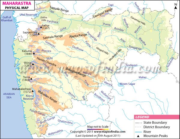
1. Location and Boundaries
- Latitude and Longitude: Maharashtra is situated between 15.60°N to 22.00°N latitude and 72.60°E to 80.90°E longitude.
- Borders: The state covers an area of 307,713 km² and is bordered by Madhya Pradesh to the north, Chhattisgarh to the east, Telangana to the southeast, Karnataka to the south, and Goa to the southwest. Gujarat lies to the northwest, with the Union territory of Dadra and Nagar Haveli sandwiched between the borders. Maharashtra boasts a coastline of 720 km along the Arabian Sea.
2. Western Ghats (Sahyadri Range)
- Mountain Range: The Western Ghats, also known as the Sahyadri range, run parallel to the western coast and are one of the prominent physical features of Maharashtra.
- Peaks: Some notable peaks include Kalsubai (the highest peak at 1,646 meters), Harishchandragad, and Matheran.
- Climate Influence: This range influences the climate of the state, especially the coastal region, by intercepting the southwest monsoon winds, resulting in heavy rainfall on the windward side.
3. Konkan Coast
- Coastal Plains: The Konkan region lies between the Western Ghats and the Arabian Sea, characterized by a narrow strip of coastal plains.
- Beaches and Ports: The coastline features beautiful beaches, cliffs, and estuaries, with important ports like Mumbai, Ratnagiri, and Alibaug.
4. Deccan Plateau
- Extent: The Deccan Plateau covers a major part of Maharashtra, including the regions of Marathwada and Vidarbha.
- Topography: It is characterized by its flat-topped hills and extensive black soil, known as regur, which is highly fertile and ideal for agriculture, particularly for cotton cultivation.
- Cities: Major cities like Pune and Nagpur are located in this region.
5. Rivers
- Godavari River: Known as the “Dakshin Ganga,” the Godavari is the longest river in Maharashtra, flowing from the western to the eastern part of the state.
- Krishna River: Another major river, the Krishna, flows through the southern part of Maharashtra.
- Other Rivers: Other significant rivers include the Bhima, Tapi, Wardha, and Wainganga. These rivers provide essential water resources for agriculture and hydroelectric power.
6. Valleys
- River Valleys: The valleys of the Godavari, Krishna, and their tributaries are fertile and densely populated, supporting extensive agriculture and settlements.
- Historical Significance: These valleys have been historically significant for trade and cultural development.
7. Forests
- Diverse Forest Types: Maharashtra’s forests include tropical evergreen, semi-evergreen, deciduous, and mangrove forests, contributing to the state’s rich biodiversity.
- Protected Areas: The state has several wildlife sanctuaries and national parks, such as the Tadoba Andhari Tiger Reserve, Sanjay Gandhi National Park, and Melghat Tiger Reserve, which protect its diverse flora and fauna.
8. Climate
- Coastal Climate: The Konkan coast experiences a humid tropical climate with heavy monsoon rains and mild winters.
- Plateau Climate: The Deccan Plateau has a more arid climate, with hot summers, moderate winters, and lower rainfall.
- Monsoon: The southwest monsoon significantly impacts the state’s climate, bringing most of the annual rainfall between June and September.
Key Geographical Regions
Konkan (Coastal Plains)
- Narrow coastal strip
- Major cities: Mumbai, Ratnagiri, Alibaug
Western Ghats
- Mountain range with biodiversity hotspot
- Hill stations: Mahabaleshwar, Lonavala, Matheran
Deccan Plateau
- Vast plateau with fertile black soil
- Major cities: Pune, Nagpur, Aurangabad
Vidarbha
- Eastern region with rich agricultural land
- Major cities: Nagpur, Amravati
Natural Resources
- Minerals: Maharashtra is rich in minerals like coal, manganese, iron ore, limestone, and bauxite.
- Agriculture: The fertile plains and plateau regions support the cultivation of crops like cotton, sugarcane, soybeans, and various fruits.
Maharashtra’s geography is marked by its varied landscape, from the coastal plains of Konkan to the rugged terrain of the Western Ghats and the expansive Deccan Plateau. This diversity influences the state’s climate, agriculture, natural resources, and overall development, making it a unique and significant region in India.
Key facts about the geography of Maharashtra
- Maharashtra is the third largest state in India by area, covering approximately 307,713 square kilometers (3 lakh sq. km).
- It shares borders with several states: Madhya Pradesh to the north, Chhattisgarh to the east, Telangana to the southeast, Karnataka to the south, and Goa to the southwest.
- The Sahyadri Range serves as the physical backbone of Maharashtra.
- The Western Ghats, also known as the Sahyadri range, runs parallel to the western coast of Maharashtra. They are a UNESCO World Heritage site and one of the world’s eight “hottest hotspots” of biological diversity.
- The Konkan region lies between the Western Ghats and the Arabian Sea. It features a narrow strip of coastal plains with beautiful beaches, cliffs, and estuaries. Important ports like Mumbai, Ratnagiri, and Alibaug are located here.
- Forests cover approximately 17% of the state’s total area, with most located in the eastern and Sahyadri regions.
- The Deccan Plateau covers a major part of Maharashtra, including the regions of Marathwada and Vidarbha. It is characterized by flat-topped hills and extensive black soil, ideal for agriculture, particularly cotton cultivation.
- Maharashtra is traversed by several major rivers. The Godavari, known as the “Dakshin Ganga,” is the longest river in the state.
- The river valleys of the Godavari, Krishna, and their tributaries are fertile and densely populated, supporting extensive agriculture and settlements.
- Important cities in Maharashtra include Mumbai, the state capital and financial hub of India, Pune, known for its educational institutions and IT industry; Nagpur, a major commercial and political center; and Aurangabad, known for its historical monuments and industrial growth.
Read Also
- Government Policies and Interventions in Maharashtra
- E-Governance and Its Applications in Maharashtra
- Urbanization and Demographic Trends in Maharashtra
- Agriculture in Maharashtra: Issues and Schemes
- Minerals of Maharashtra
- Districts and Divisions of Maharashtra
- GI Tag Products of Maharashtra
- Celebrating Maharashtra Day
- The Rich Art and Sculpture of Maharashtra
- Cultural Heritage of Maharashtra
- Exploring Maharashtra’s Rich Heritage

Frequently Asked Questions (FAQs)
A1: Maharashtra can be broadly divided into three major physical regions:
The Western Ghats (Sahyadri Range): A mountain range running parallel to the western coast.
The Konkan Coast: A narrow strip of coastal plains between the Western Ghats and the Arabian Sea.
The Deccan Plateau: An extensive plateau covering much of the state, including regions like Marathwada and Vidarbha.
A2: The highest peak in Maharashtra is Kalsubai, which is located in the Western Ghats and has an elevation of 1,646 meters (5,400 feet) above sea level.
A3: The major rivers flowing through Maharashtra include:
Godavari: The longest river in the state, also known as “Dakshin Ganga.”
Krishna: Another major river supporting agriculture and hydroelectric projects.
Bhima, Tapi, Wardha, and Wainganga: Other significant rivers contributing to the state’s water resources.
A4: Maharashtra is predominantly covered by black soil, also known as regur soil, especially in the Deccan Plateau region. This soil is highly fertile and ideal for cotton and sugarcane cultivation.
A5: The Konkan Coast is significant for its scenic beauty, rich biodiversity, and economic importance. It features beautiful beaches, fishing villages, and major ports like Mumbai, which is a crucial hub for trade and commerce.
A6: Major cities located on the Deccan Plateau in Maharashtra include Pune and Nagpur. Pune is known for its educational institutions and IT industry, while Nagpur is a significant commercial and political center.
Your point of view caught my eye and was very interesting. Thanks. I have a question for you.