


India, the seventh-largest country in the world, boasts a spectacularly diverse physical geography. From the towering, snow-clad peaks of the mighty Himalayas in the north to the tranquil coastal plains caressed by the Bay of Bengal and Arabian Sea in the south, the Indian subcontinent is a land of remarkable natural variety. This diversity is not just breathtaking in its beauty—it is deeply rooted in the country’s complex geological history, shaped over millions of years by tectonic movements, erosion, and climatic changes. The physical features of India span from the towering Himalayas in the north to the sun-drenched coastal plains in the south, creating a diverse landscape of mountains, rivers, deserts, and plateaus that shape the nation’s climate, culture, and history.
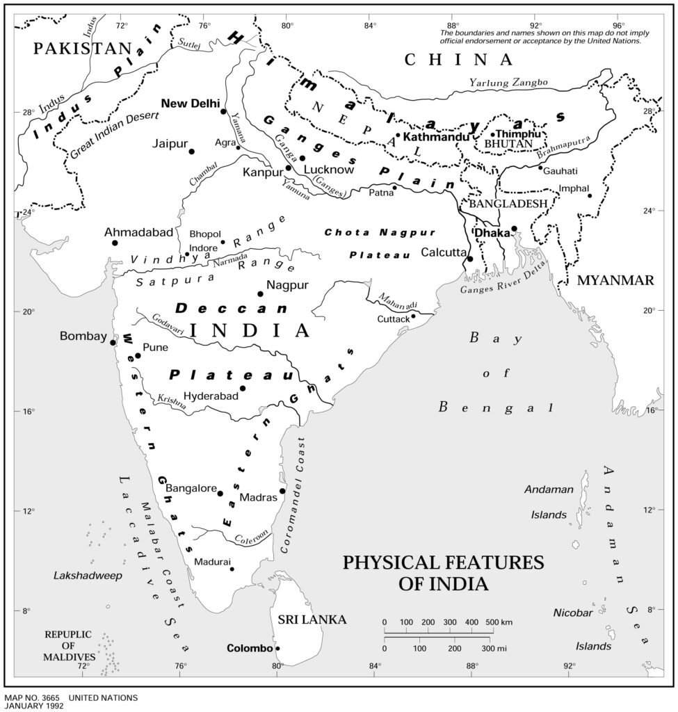
India’s physical features span every imaginable terrain: high-altitude mountain ranges, fertile river valleys, rugged plateaus, arid deserts, lush forests, and tropical islands. Each region tells a different story—of ancient landmasses colliding, rivers depositing fertile alluvium, and seas shaping coastlines. These natural formations have given rise to distinct ecological zones, varied agricultural patterns, and rich biodiversity, contributing to India’s uniqueness both environmentally and culturally.
Moreover, these physical features have profoundly influenced settlement patterns, economic activities, transportation networks, and even spiritual beliefs across the country. Civilizations flourished on riverbanks, trade routes developed across plateaus, and sacred sites were nestled in the Himalayas—all interwoven with the land’s physical form. Understanding these landforms is essential to appreciating India’s natural wealth and the intricate relationship between its people, land, and legacy.
India’s landmass can be broadly categorized into six major physical divisions:
- The Himalayan Mountains
- The Northern Plains
- The Peninsular Plateau
- The Indian Desert (Thar Desert)
- The Coastal Plains
- The Islands
Let’s explore each of these in detail.
1. The Himalayan Mountains
📍 Location: Northern boundary of India
🌍 Type: Young fold mountains
The Himalayan Mountains form the majestic northern frontier of India, extending over 2,500 kilometers and stretching across five countries—India, Nepal, Bhutan, China, and Pakistan. These mountains are part of the youngest and loftiest mountain range in the world, born from the tectonic collision between the Indian Plate and the Eurasian Plate around 50 million years ago. This geological upheaval not only created these awe-inspiring peaks but also continues to push them upward at a rate of a few centimeters per year, making the Himalayas a dynamic and ever-changing landscape.
🧭 Geographical Significance:
The Himalayas serve as a natural boundary, climatic divide, and cultural barrier between the Indian subcontinent and the Tibetan Plateau. They play a crucial role in shaping India’s weather patterns, especially in blocking icy winds from Central Asia and enabling the monsoon winds to bring rainfall to northern India.
🔍 Key Features of the Himalayan Mountains:
🏔️ 1. Greater Himalayas (Himadri)
- The northernmost and highest range, this section contains the world’s tallest peaks.
- Home to Mount Everest (8,848 m), located along the Nepal-China border, and Kanchenjunga (8,586 m)—India’s highest peak and the third-highest in the world.
- Features permanent snowfields and glaciers such as the Gangotri and Siachen, which are vital sources of freshwater.
- Sparsely populated due to harsh climate, thin air, and rugged terrain, but of immense strategic and spiritual importance.
⛰️ 2. Lesser Himalayas (Himachal)
- Located south of the Himadri, this middle range consists of mountains with elevations between 1,500 to 4,500 meters.
- Known for picturesque valleys, coniferous forests, and charming hill stations like Shimla, Manali, Dharamshala, and Nainital.
- Rich in natural resources, supporting agriculture and human settlements.
- The region is prone to landslides and seismic activity, given its geologically active nature.
🏞️ 3. Shiwalik Hills
- The southernmost and youngest range of the Himalayas, with elevations ranging from 600 to 1,200 meters.
- Formed by alluvial deposits carried down by rivers from the higher ranges.
- Known for the bhabar and terai regions at their foothills, fertile and agriculturally productive zones.
- Densely populated, especially in the foothill regions across Uttarakhand, Himachal Pradesh, and Jammu.
🌊 Hydrological Importance: Source of Lifeline Rivers
The Himalayas are the cradle of India’s great river systems, giving birth to:
- The Ganga River, emerging from the Gangotri Glacier in Uttarakhand
- The Yamuna River, originating from the Yamunotri Glacier
- The Brahmaputra River, starting from Tibet as the Tsangpo, before entering Arunachal Pradesh
- The Indus River, rising in Tibet and flowing through Ladakh into Pakistan
These rivers support the Indo-Gangetic Plains, one of the most fertile and densely populated regions on Earth.
❄️ Climatic Influence and Natural Barrier
- Acts as a climatic shield, protecting the Indian subcontinent from the cold Siberian winds.
- Plays a central role in monsoon circulation by trapping the south-west monsoon winds, resulting in heavy rainfall on the southern slopes.
- The presence of snow-capped peaks and glaciers contributes to perennial river flow, ensuring year-round water availability for irrigation and hydropower.
🧗♀️ Tourism, Spiritual Significance, and Biodiversity
- The Himalayas are dotted with pilgrimage sites such as Badrinath, Kedarnath, Vaishno Devi, and Amarnath, attracting millions of devotees annually.
- The region is rich in biodiversity, home to species like the snow leopard, red panda, and Himalayan monal.
- A paradise for adventurers, offering trekking, mountaineering, skiing, and wildlife exploration.
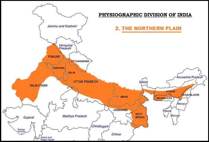
2. The Northern Plains
📍 Location: South of the Himalayas
🌊 Type: Alluvial plains
The Northern Plains of India, also known as the Indo-Gangetic Plains, are among the most geographically and economically significant regions of the country. These expansive lowlands stretch over 2,500 kilometers from the Punjab region in the west to the Brahmaputra valley in the east, covering an area of more than 7 lakh square kilometers. They are formed by the accumulation of rich alluvial soil deposited by three major river systems—the Indus, Ganga, and Brahmaputra—over millions of years.
This region is not just the breadbasket of India, but also a cultural heartland, housing some of the most ancient and continuously inhabited cities in the world. Its flat terrain, fertile soils, abundant water supply, and favorable climate have supported dense populations, advanced agriculture, and urban development for centuries.
🔍 Key Features of the Northern Plains
🗺️ 1. Punjab Plains (Indus Basin)
- Located in Punjab and Haryana, these plains are watered mainly by the Indus River and its five tributaries—Jhelum, Chenab, Ravi, Beas, and Sutlej.
- Known for extensive canal irrigation, making it one of the most agriculturally productive regions.
- Famous for growing wheat, sugarcane, mustard, and pulses.
- Cities like Amritsar, Ludhiana, and Chandigarh thrive in this region.
🌾 2. Ganga Plains (Uttar Pradesh and Bihar)
- This is the largest section of the Northern Plains, stretching from Uttarakhand to West Bengal.
- Formed by the Ganga and its tributaries like Yamuna, Ghaghara, Gandak, and Kosi.
- Known for its deep, fertile alluvial soils, ideal for rice, wheat, maize, and sugarcane cultivation.
- Contains major urban centers such as Delhi, Agra, Varanasi, Patna, and Lucknow.
- Also home to historical and spiritual landmarks, including Kashi (Varanasi), Prayagraj, and Ayodhya.
🌊 3. Brahmaputra Plains (Assam and Northeast)
- Encompasses the floodplains of the Brahmaputra River, particularly in Assam and parts of Arunachal Pradesh.
- Subject to annual flooding, but the soil is extremely fertile, supporting rice, jute, and tea cultivation.
- Known for its unique riverine islands, including Majuli, the world’s largest river island.
- Rich in biodiversity, with wildlife sanctuaries like Kaziranga National Park.
🌱 Agricultural Powerhouse
The Northern Plains are often referred to as the “Granary of India” due to their unmatched contribution to food production. Thanks to:
- Fertile alluvial soil, renewed annually by river floods
- Flat terrain is ideal for mechanized farming
- Extensive irrigation systems, including canals and tube wells
- A favorable climate for rabi and kharif crops
The region grows a wide variety of crops, like:
- Wheat, rice, sugarcane, pulses, oilseeds, and vegetables
🏙️ Urbanization and Population Density
- The Northern Plains support some of the highest population densities in India.
- Several metropolitan and Tier-2 cities are located here due to the easy availability of water, fertile land, and flat terrain.
- Cities like Delhi, Kolkata, Kanpur, Lucknow, and Patna are important hubs for administration, education, commerce, and transportation.
🧭 Geographical and Cultural Importance
- Acts as a corridor connecting eastern and western India.
- The Ganga River holds immense spiritual significance, with numerous ghats, temples, and festivals centered around it.
- Historical cities like Delhi, Varanasi, and Patna have been centers of power, learning, and culture for millennia.
3. The Peninsular Plateau
📍 Location: Central and Southern India
🪨 Type: Ancient crystalline igneous and metamorphic rocks
The Peninsular Plateau is a vast tableland that occupies a major portion of southern India. It is one of the oldest and most stable geological formations in the world, dating back to the Precambrian era, and was formed by the fragmentation of the supercontinent Gondwana over 200 million years ago. This plateau has withstood massive geological changes, including tectonic shifts, volcanic activity, and erosion over millions of years.
Triangular in shape, it is bounded by the Aravalli Hills in the northwest, the Western Ghats in the west, the Eastern Ghats in the east, and merges into the plains of the Ganga and Mahanadi in the north. Its average elevation ranges between 600–900 meters above sea level, and it gently slopes eastward, allowing rivers to flow into the Bay of Bengal.
🔍 Key Features of the Peninsular Plateau:
🗺️ 1. Deccan Plateau (South of the Narmada River)
- This is the largest part of the plateau, covering most of Maharashtra, Karnataka, Andhra Pradesh, Tamil Nadu, and parts of Telangana.
- It is bordered by the Western Ghats on the west and the Eastern Ghats on the east.
- Composed of volcanic basalt rocks, it is known for its fertile black soil or regur soil, ideal for cotton cultivation.
- Rivers like the Godavari, Krishna, and Kaveri originate here and flow eastward, forming fertile deltas.
- Known for rich deposits of iron ore, manganese, and bauxite.
⛰️ 2. Central Highlands (North of the Narmada River)
- This region includes the Malwa Plateau, Bundelkhand Plateau, and parts of Rajasthan and Madhya Pradesh.
- Bounded by the Aravalli Range in the northwest and the Vindhya Range to the south.
- The Chambal, Betwa, and Ken rivers drain this area, creating deep ravines and gorges.
- The soil is less fertile, mostly composed of red and yellow soils, but it still supports agriculture with irrigation.
🌄 3. Chotanagpur Plateau (Eastern Part)
- Often called the “Ruhr of India”, this region covers Jharkhand, parts of Chhattisgarh, Odisha, and West Bengal.
- Rich in coal, iron ore, mica, and other minerals, making it a hub for mining and heavy industries.
- The Damodar Valley, a major coal belt, lies here and is vital for thermal power generation.
- Features rugged terrain, dense forests, and tribal settlements.
🪨 Geological and Economic Significance
- The Peninsular Plateau is primarily composed of igneous and metamorphic rocks such as granite, gneiss, and schist.
- It is a storehouse of mineral wealth, especially in the eastern and central regions.
- The terrain is undulating with occasional hills, plateaus, and valleys, resulting from prolonged erosion and tectonic stability.
- Important hill ranges include the Satpura, Vindhya, Mahadeo, and Ajanta Hills.
🌿 Soil and Agriculture
The plateau has varied soil types:
- Black soil (regur): Found in the Deccan region, ideal for cotton, sugarcane, and pulses.
- Red and yellow soil: Common in Karnataka, Tamil Nadu, Odisha, and Chhattisgarh, suitable for millets, groundnuts, and coarse grains.
- Laterite soil: Found on hilltops with heavy rainfall, useful for tea, coffee, and cashew cultivation.
Though irrigation is limited compared to the Northern Plains, agriculture thrives due to groundwater use, tank irrigation, and monsoon rains.
🧭 Cultural and Environmental Significance
- Home to ancient civilizations and temple towns like Hampi, Badami, Pattadakal, and Madurai.
- Rich in tribal cultures in regions like Bastar and Chotanagpur.
- Important forest belts such as those in Kanha, Bandipur, and Nagarhole support diverse flora and fauna.
- Offers eco-tourism, adventure activities, and spiritual tourism.
4. The Indian Desert
📍 Location: Western Rajasthan
🌡️ Type: Arid region
The Thar Desert, also known as the Great Indian Desert, is a vast arid region that stretches across the northwestern part of India, primarily in Rajasthan, and extends into Punjab, Haryana, and parts of Gujarat. Covering an area of approximately 200,000 square kilometers, it is the 17th largest desert in the world and the most densely populated desert globally. Despite its harsh climate and limited vegetation, the Thar Desert is a vibrant and culturally rich region, deeply interwoven with India’s heritage and identity.
The desert lies to the east of the Indus River and is largely a result of the rain shadow effect caused by the Aravalli Hills, which block the southwest monsoon winds from reaching this region. As a result, the area receives very little rainfall, leading to dry, sandy conditions and extreme temperature variations between day and night.
🔍 Key Features of the Thar Desert:
🌧️ Rainfall and Climate
- Receives less than 150 mm of rainfall annually, with most of it falling during a very short monsoon season (July to September).
- Experiences extreme temperatures, with summers reaching up to 50°C and winters dropping to near-freezing levels at night.
- High wind activity results in shifting sand dunes and occasional dust storms.
🌵 Vegetation and Landscape
- Vegetation is sparse and consists mostly of xerophytic (drought-resistant) plants like cacti, acacia, khejri, babool, and various thorny shrubs.
- The terrain is marked by sand dunes (barchans), rocky plateaus, salt flats, and occasional oases.
- The region is gradually being transformed through afforestation and desert reclamation projects, especially in the Indira Gandhi Canal area.
🏙️ Major Cities and Settlements
- Jaisalmer: Known as the “Golden City”, famous for its sandstone fort, havelis, and desert architecture.
- Bikaner: A historical city known for its camel breeding farm, palaces, and traditional sweets.
- Barmer and Nagaur are other important desert towns.
- Despite harsh conditions, these cities thrive with distinctive art, music, cuisine, and architecture.
🐪 Cultural Heritage and Livelihoods
- The Thar Desert is a land of rich folk traditions, expressed through colorful attire, music, dance, and handicrafts.
- Famous dance forms like Ghoomar and Kalbelia, and instruments like dholak and sarangi, originate here.
- Camel caravans, once the lifeline of trade, are now a part of the tourism industry, offering camel safaris across the dunes.
- Handicrafts, embroidery, leatherwork, and pottery are major sources of livelihood, especially for women.
- Annual events like the Desert Festival of Jaisalmer draw global tourists with camel races, folk performances, and cultural exhibitions.
🚜 Agriculture and Economy
- Agriculture is largely rain-fed and uncertain, but locals cultivate millets, pulses, barley, and mustard using traditional water conservation techniques.
- The introduction of the Indira Gandhi Canal has brought irrigation water to parts of the desert, transforming the landscape in some areas and enabling farming.
- Animal husbandry, particularly of camels, goats, and sheep, is an integral part of the desert economy.
🐆 Wildlife and Ecology
Protected areas like the Desert National Park near Jaisalmer help conserve the fragile desert ecosystem.
The Thar is home to unique desert wildlife such as:
Indian gazelle (chinkara)
Desert fox
Great Indian Bustard (critically endangered)
Monitor lizard, caracal, and sand boa
5. The Coastal Plains
📍 Location: Along the eastern and western shores of the Indian Peninsula
🌊 Type: Sedimentary plains
India, with a coastline spanning over 7,500 kilometers, boasts some of the most geographically diverse and culturally rich coastal regions in the world. These coastal stretches are divided into two distinct plains—the Eastern Coastal Plain along the Bay of Bengal and the Western Coastal Plain along the Arabian Sea. These plains have not only played a crucial role in India’s maritime history and trade but also support dense human settlements, agriculture, and thriving tourism.
These low-lying plains were primarily formed by the deposition of sediments brought by rivers and the action of sea waves. They vary significantly in width, topography, soil fertility, and natural features, and are home to bustling port cities, serene backwaters, river deltas, and vibrant ecosystems.
🌅 Eastern Coastal Plain
📍 Extends from West Bengal in the north to Tamil Nadu in the south
📏 Broader, flatter, and more extensive than the western counterpart
The Eastern Coastal Plain lies between the Eastern Ghats and the Bay of Bengal, encompassing states like West Bengal, Odisha, Andhra Pradesh, and Tamil Nadu. These plains are relatively wider (up to 120 km in some places) and more fertile due to the deposition of riverine alluvium from major rivers flowing eastward.
🔍 Key Features:
- Major Rivers: Mahanadi, Godavari, Krishna, Cauvery
- These rivers form some of the largest deltas in the world, such as the Godavari Delta and the Cauvery Delta, which are agriculturally very productive.
- Landforms: Includes deltas, lagoons, estuaries, and marshes
- Soil: Rich alluvial soil, ideal for growing rice, pulses, coconut, and sugarcane
- Natural Attractions: Chilika Lake (Asia’s largest brackish water lagoon), Pulicat Lake, and Muthupet wetlands
- Major Cities: Chennai, Visakhapatnam, Bhubaneswar, Kakinada
- Climatic Conditions: Hot and humid, with rainfall from both southwest and northeast monsoons
The Eastern Coastal Plain is also highly vulnerable to cyclones and coastal erosion, particularly in the Bay of Bengal region, necessitating extensive disaster management systems.
🌴 Western Coastal Plain
📍 Extends from Gujarat in the north to Kerala in the south
📏 Narrower and steeper compared to the Eastern Coastal Plain
The Western Coastal Plain lies between the Western Ghats and the Arabian Sea, covering parts of Gujarat, Maharashtra, Goa, Karnataka, and Kerala. This plain is much narrower, averaging 50–80 km in width, and is interspersed with short, swift-flowing rivers that form estuaries rather than deltas.
🔍 Key Features:
- Major Rivers: Tapi, Narmada, Mandovi, Zuari, Periyar
- Unlike the eastern rivers, most of these are non-deltaic, flowing directly into the Arabian Sea.
- Landforms: Features sandy beaches, rocky cliffs, estuaries, lagoons, and coral reefs
- Natural Attractions: Famous for backwaters in Kerala, including Vembanad Lake, and beaches in Goa and the Konkan coast
- Port Cities: Mumbai, Mangalore, Kochi, Goa
- These cities are crucial hubs for international trade, fishing, and naval operations
- Agriculture: Focuses on plantation crops like coconut, areca nut, spices, and rice in wetland areas
- Climate: Receives heavy rainfall from the southwest monsoon, especially along the Malabar Coast
The Western Coastal Plain is also significant for its biodiversity, especially in the Western Ghats region, which is a UNESCO World Heritage Site and one of the eight “hottest hotspots” of biological diversity in the world.
🚢 Importance of Coastal Plains in India
- Agricultural Fertility: River deltas and alluvial soils support intensive farming.
- Ports and Trade: Major ports like Mumbai, Chennai, Kochi, Visakhapatnam, and Kandla facilitate international trade.
- Fisheries and Marine Resources: These coastal zones contribute significantly to India’s seafood industry.
- Tourism: The coasts are popular for beach tourism, cultural festivals, water sports, and eco-tourism.
- Disaster Vulnerability: Coastal areas are often exposed to tsunamis, sea-level rise, and cyclones, especially in the Bay of Bengal region.
6. The Islands
India is not only defined by its vast landmass but also by its strategically located and ecologically rich island groups, which form an integral part of the country’s physical geography. There are two major groups of islands—the Andaman and Nicobar Islands in the Bay of Bengal and the Lakshadweep Islands in the Arabian Sea. Both groups hold immense importance in terms of geopolitics, ecology, biodiversity, defense, and tourism.
🌋 Andaman and Nicobar Islands
📍 Bay of Bengal, southeastern edge of the Indian subcontinent
🪨 Volcanic origin (part of a submerged mountain chain)
- Comprising over 570 islands, only a few of which are inhabited, this archipelago stretches over 700 km and acts as a strategic maritime frontier.
- These islands are of volcanic and tectonic origin, formed by the subduction of the Indian plate beneath the Burmese plate.
- Home to dense tropical rainforests, mangroves, and a rich variety of flora and fauna, including many endemic species.
- Known for the active Barren Island Volcano, the only confirmed active volcano in South Asia.
- Rich in marine biodiversity, the islands are a paradise for scuba diving, snorkeling, coral reef exploration, and adventure tourism.
- Historically significant with landmarks like the Cellular Jail in Port Blair, a symbol of India’s freedom struggle.
🐚 Lakshadweep Islands
📍 Arabian Sea, off the southwestern coast of India
🪸 Coral origin (atolls, reefs, and submerged banks)
- The Lakshadweep group consists of 36 islands, most of which are tiny coral atolls, forming a unique ecosystem in the Arabian Sea.
- Unlike the Andamans, these islands are flat, low-lying, and fragile in structure, mostly composed of white sandy beaches and coconut palms.
- The region is ecologically sensitive and known for its lagoon fisheries, coral reefs, seagrass meadows, and marine turtles.
- It is India’s smallest Union Territory, yet it plays a crucial role in marine research, oceanic studies, and eco-tourism.
- Activities such as kayaking, canoeing, and reef walks attract tourists interested in low-impact, sustainable tourism.
🌐 Importance of India’s Physical Features
India’s physical features are not just natural landmarks—they are the foundation of the country’s ecological balance, socio-economic development, and cultural identity. Each geographical region contributes uniquely to India’s overall landscape, climate, resources, and population patterns.
🌦️ 1. Climate Regulation
- The Himalayas act as a natural barrier, preventing icy Arctic winds from sweeping across the subcontinent, thus maintaining the temperate climate in northern India.
- The Thar Desert contributes to the formation and pull of the southwest monsoon, which brings crucial rainfall.
- Coastal regions moderate temperatures and support humid tropical climates, essential for crops like rice and coconut.
🌾 2. Agriculture and Food Security
- The alluvial soils of the Northern Plains and the delta regions of the East Coast support intensive agriculture, feeding a large population.
- The black soil of the Deccan Plateau is perfect for cotton, while red and laterite soils sustain diverse cropping in peninsular regions.
- Hill regions like the Western Ghats support plantation agriculture (tea, coffee, spices).
🦜 3. Biodiversity and Ecology
- India’s varied landforms—forests, deserts, wetlands, coastlines, and mountains—host an incredibly diverse range of flora and fauna, many of which are endemic or endangered.
- Natural habitats support tiger reserves, elephant corridors, biosphere reserves, and mangrove ecosystems.
🕌 4. Cultural and Historical Diversity
- Geography influences language, clothing, food, architecture, festivals, and religious practices.
- Sacred rivers like the Ganga, holy mountains like Kailash, and spiritual forests have shaped faiths and pilgrimages.
- Ancient civilizations flourished on riverbanks (Indus Valley, Ganga-Yamuna Doab), on plateaus, and coastal trade centers.
🔋 5. Economic Resources and Development
- Plateaus are rich in minerals and energy resources (coal, iron, bauxite).
- Rivers and mountain slopes are harnessed for hydroelectricity.
- Coastal and island regions support fisheries, ports, international trade, and tourism.
- The Western and Eastern Ghats contribute to climate resilience, rainfall distribution, and medicinal plant diversity.
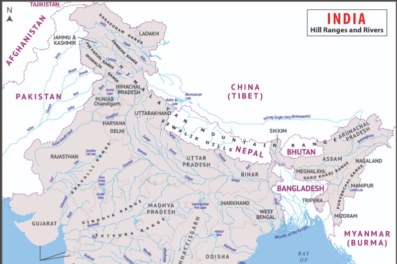
7. River Systems
India’s vast and dynamic river systems play an essential role in shaping the nation’s landscape, agriculture, culture, and settlement patterns. Flowing across diverse terrains—from snow-capped mountains to coastal plains—these rivers are not only lifelines for millions but also crucial elements of the country’s physical geography.
India’s rivers are broadly categorized into Himalayan rivers and Peninsular rivers, based on their origin. The Himalayan rivers are perennial, fed by glaciers and snowmelt, while the Peninsular rivers are largely rain-fed and seasonal.
🕉️ The Ganges River System
📍 Origin: Gangotri Glacier, Uttarakhand
🌍 Drainage: Northern Plains → Bay of Bengal
The Ganges (Ganga) is the most revered and sacred river in India, holding immense religious, cultural, and economic importance. It flows over 2,500 km, nourishing the fertile Indo-Gangetic Plains and supporting hundreds of millions of people along its banks.
- Major Tributaries: Yamuna, Ghaghara, Gandak, Kosi, Son
- Key Cities: Rishikesh, Haridwar, Kanpur, Varanasi, Patna, Kolkata
- The Ganga Delta, formed by the confluence of the Ganga and Brahmaputra, is the largest delta in the world.
- It supports intensive agriculture, mainly rice and wheat cultivation, along with a dense population.
Culturally, the Ganga is seen as a goddess and is the site of many rituals, festivals, and pilgrimages, such as the Kumbh Mela.
🌏 The Brahmaputra River System
📍 Origin: Angsi Glacier (Tibet)
🌊 Names: Tsangpo (Tibet), Siang (Arunachal), Brahmaputra (India)
The Brahmaputra River travels a long journey through Tibet, India, and Bangladesh, playing a key role in the geography and ecosystem of northeast India. It enters India through Arunachal Pradesh and flows through Assam before joining the Ganga in Bangladesh.
- Known for its massive volume and strong currents, especially during the monsoon.
- The Brahmaputra Valley is home to rich alluvial soil, supporting rice, jute, and tea cultivation.
- Subject to frequent flooding, which shapes the floodplains but also causes damage.
- Important cities: Dibrugarh, Tezpur, Guwahati
This river system sustains the Kaziranga and Manas National Parks, both UNESCO World Heritage Sites, and is vital for Assam’s biodiversity.
🏞️ The Indus River System
📍 Origin: Tibetan Plateau, near Lake Mansarovar
🌐 Main Course: Through Ladakh (India) and Pakistan
The Indus River was the cradle of the Indus Valley Civilization, one of the world’s oldest urban cultures. Although it now primarily flows through Pakistan, several important tributaries flow through northern India, especially Punjab and Himachal Pradesh.
- Major Indian Tributaries: Jhelum, Chenab, Ravi, Beas, Sutlej
- These rivers together form the Punjab (Land of Five Rivers)
- This system is the backbone of the Indo-Pak water-sharing agreements under the Indus Waters Treaty
- Supports irrigation, hydropower, and agriculture in India’s northwestern region
The Indus system is of strategic, agricultural, and geopolitical importance, particularly for Jammu & Kashmir and Punjab.
🛶 The Peninsular River Systems
The Peninsular rivers originate mainly from the Western Ghats and flow eastward into the Bay of Bengal, with a few exceptions that flow westward into the Arabian Sea. These rivers are older than their Himalayan counterparts and mostly seasonal, depending on monsoon rainfall.
📍 Major East-Flowing Rivers:
- Godavari – Often called the Dakshina Ganga (Ganga of the South), it’s the longest river in peninsular India.
- Origin: Nasik, Maharashtra
- Flows through Telangana, Andhra Pradesh
- Forming the Godavari Delta, one of the most fertile regions
- Krishna – Flows from Maharashtra to Andhra Pradesh via Karnataka.
- Supports major projects like Almatti and Nagarjuna Sagar Dams
- Cauvery (Kaveri) – Sacred river of Tamil Nadu and Karnataka.
- Supports intensive agriculture, especially in the Kaveri Delta
- Site of cultural landmarks like Srirangam and Kumbakonam
- Mahanadi – Flows through Chhattisgarh and Odisha
- Known for the Hirakud Dam, one of the longest in Asia
📍 Major West-Flowing Rivers:
- Narmada – Originates from Amarkantak in Madhya Pradesh; flows into the Arabian Sea
- Carves out the famous Marble Rocks at Bhedaghat
- Forms the boundary between North and South India
- Tapi (Tapti) – Originates from the Satpura range; flows through Madhya Pradesh, Maharashtra, and Gujarat
- Important for irrigation and hydroelectricity
- Mahi and Sabarmati – Smaller rivers supporting agriculture in western India
8. The Western and Eastern Ghats
📍 Location: Flanking the Deccan Plateau on the western and eastern edges
⛰️ Type: Block mountains (Western Ghats), discontinuous hills (Eastern Ghats)
India’s Western and Eastern Ghats are two prominent mountain ranges that run parallel to the country’s western and eastern coastlines, respectively. They play a crucial role in shaping India’s climate, ecology, and biodiversity, and are among the most geologically and environmentally significant features of the subcontinent.
🌄 Western Ghats (Sahyadri Hills)
📍 Location: Runs parallel to the western coast from Gujarat to Kerala
🌍 UNESCO World Heritage Site
The Western Ghats, also known as the Sahyadri Hills, are a continuous mountain chain stretching approximately 1,600 km along the western edge of the Deccan Plateau. They are steep and rugged, with elevations often exceeding 2,000 meters.
🔍 Key Features:
- Highest Peak: Anamudi (2,695 m) in Kerala
- States Covered: Gujarat, Maharashtra, Goa, Karnataka, Kerala, Tamil Nadu
- Climatic Role: Blocks the southwest monsoon winds, resulting in heavy rainfall on the western side and a rain shadow effect on the eastern side
- Biodiversity Hotspot:
- One of the world’s eight “hottest hotspots” of biodiversity
- Home to endemic species such as the Lion-tailed macaque, Nilgiri tahr, and Malabar civet
- Rivers Originating: Godavari, Krishna, Kaveri, Tungabhadra, and Periyar have their sources in these hills
- Soil: Laterite and red soils, suitable for spices, coffee, tea, and rice cultivation
- Tourism and Culture: Scenic hill stations like Munnar, Wayanad, Mahabaleshwar, Coorg, and Ooty are popular destinations
The Western Ghats are not only vital for ecology and agriculture but are also culturally rich, with many ancient temples, monasteries, and sacred groves nestled in their folds.
⛰️ Eastern Ghats
📍 Location: Runs along the eastern coast from Odisha to Tamil Nadu
🌄 Discontinuous and Eroded
The Eastern Ghats are a discontinuous range of hills that stretch from Odisha through Andhra Pradesh and Tamil Nadu. Unlike the Western Ghats, they are lower in elevation and more eroded, as they are older and have been weathered by natural forces over time.
🔍 Key Features:
- Highest Peak: Arma Konda (1,680 m) in Andhra Pradesh
- Rivers: Major rivers such as the Mahanadi, Godavari, Krishna, and Kaveri cut through the Eastern Ghats to reach the Bay of Bengal
- Vegetation: Mixture of deciduous forests and scrub vegetation, interspersed with agricultural lands
- Soil Types: Laterite, red, and black soils support the cultivation of millets, pulses, oilseeds, and rice
- Cultural Importance: Home to ancient tribal communities and pilgrimage sites like Tirupati (Andhra Pradesh) and Simhachalam
Though less prominent in height, the Eastern Ghats are ecologically fragile and rich in mineral resources, including bauxite and limestone, making them important for both environmental conservation and economic development.
🧭 Comparative Overview: Western vs Eastern Ghats
| Feature | Western Ghats | Eastern Ghats |
|---|---|---|
| Continuity | Continuous range | Discontinuous and fragmented |
| Orientation | North to South (parallel to the west coast) | North-East to South-West (along the east coast) |
| Average Elevation | 900–1,600 m (up to 2,695 m) | 600–1,000 m (max ~1,680 m) |
| Rainfall | High (due to monsoon barrier effect) | Moderate (rain shadow region) |
| Rivers | Source of major peninsular rivers | Rivers cut through and flow eastward |
| Biodiversity | Very high; many endemic species | Moderate; less diverse flora/fauna |
| UNESCO Heritage Site | Yes (recognized in 2012) | No |
9. The Coastal Regions
India’s extensive coastline stretches over 7,500 km, encompassing the Eastern and Western Coastal Plains. These coastal regions play a vital role in the country’s climate, economy, agriculture, and tourism.
- The Eastern Coastal Plain, broader and flatter, lies between the Eastern Ghats and the Bay of Bengal, and features fertile deltas of rivers like the Mahanadi, Godavari, Krishna, and Kaveri.
- The Western Coastal Plain, narrower and more rugged, runs between the Western Ghats and the Arabian Sea, with short rivers like the Tapi, Narmada, and Periyar, and is known for its beaches, backwaters, and port cities.
These regions support dense populations, vibrant maritime trade, and a variety of ecosystems and cultural practices unique to India’s coastal life.
10. The Valleys and Plateaus
India’s landscape is richly adorned with numerous valleys and plateaus, each shaped by ancient geological forces and contributing uniquely to the country’s physical and cultural diversity.
🏞️ Valleys of India
Valleys in India are primarily found in the Himalayan region and the Western Ghats, formed by river erosion and tectonic activity.
- Kashmir Valley: Nestled between the Greater Himalayas and the Pir Panjal range, it is known for its scenic beauty, rich culture, and fertile lands.
- Kangra and Kullu Valleys: Located in Himachal Pradesh, popular for tourism and agriculture.
- Brahmaputra Valley: A broad river valley in Assam, vital for rice cultivation and tea plantations.
These valleys are not only fertile and densely populated but also key to India’s agriculture, biodiversity, and tourism.
🪨 Plateaus of India
The Peninsular Plateau, one of the oldest landforms in India, dominates the central and southern regions. It is a tableland made of igneous and metamorphic rocks, rich in minerals and natural resources.
- Deccan Plateau: Covers a large part of southern India, bounded by the Western and Eastern Ghats, and is known for its black soil, ideal for cotton farming.
- Malwa Plateau: Located in central India, it supports wheat and soybean cultivation.
- Chotanagpur Plateau: Found in Jharkhand and surrounding areas, it is India’s mining heartland, rich in coal, iron, and bauxite.
Plateaus offer a stable climate, support tribal communities, and are vital for hydropower generation, forest cover, and mineral wealth.
India’s physical features reflect a harmonious blend of old and new, rugged and fertile, high and low. Each region tells a story of its geological past and continues to shape the present through economic activity, population distribution, and cultural richness. Understanding India’s physical geography is not just about landforms—it’s about understanding the soul of a civilization that thrives across climates, terrains, and ages.
Also Read
- Exploring the Rich Tapestry of Marathi Language and Literature
- Driest Place in India – Jaisalmer
- Languages and Dialects of Madhya Pradesh
- Language Immersion Programs
- India’s UNESCO World Heritage Sites
- Co-operative Dairies in India
- PAN 2.0: Revolutionizing India’s Tax System
- Indian States Zones
- States and Capitals of India – 2024
- Major Stadiums in India
- National Identity Card India
- Foundation Day of States in India
- Important Mountain Passes in India
- River Delta Ecosystems
- Brahmaputra: A Mighty River
- Mawsynram: Discover the Wettest Place in India and the World
- Chenab River Bridge: World’s Highest Railway Arch Bridge in India
- Unique features of Indian plateaus

Non-Toxic & BPA Free Bottles | Eco Friendly Water Bottle (900 ml)
Drinking water in a meena print pure copper bottle 900 ml (900 ml) helps you to look younger and feels freshness. Silicone seal ensures no leakage in copper bottles. The pure copper ensures maximum conductivity. Perfectly hand crafted, rust free and easy to clean. Ayurvedic health benefits and feels a great experience in your dining room.
Frequently Asked Questions (FAQs)
India is divided into four primary geographical regions: the Himalayas, the Deccan Traps, the Indo-Gangetic Plain, and the Coastal Plains.
The Himalayas run parallel to India’s northern border, forming part of the mountain ranges that extend through Nepal, Bhutan, China, Afghanistan, Pakistan, Bangladesh, and Myanmar.
India’s Deccan Traps contain abundant reserves of minerals such as iron ore, gold, diamonds, copper, and bauxite, playing a crucial role in the country’s mining industry.
Monsoon season plays a vital role in Indian agriculture, providing much-needed rainwater necessary for crop cultivation. Farmers rely heavily on monsoons for irrigation, planting seeds, and harvesting crops.
The highest point in India is K2, located in the Himalayas on the border with China and Pakistan.
The Indus and Ganges rivers are the major river systems in India. The Brahmaputra River, which joins the Ganges to form the world’s largest delta, also plays a significant role.
The mountains, rivers, plains, and deserts have all played a significant role in shaping the course of Indian history and culture. The fertile plains fostered the development of agriculture and civilizations, while the mountains provided natural barriers and influenced trade routes.
Some of the challenges include managing water resources effectively, mitigating the impact of floods and droughts, and addressing issues like deforestation and soil erosion.