


India is a vast and diverse country, divided into 28 states and 8 Union Territories, each with its own unique culture, language, geography, and historical significance. People often categorize India into zones based on geographic, administrative, and cultural factors to manage its size and complexity. These Indian state zones play a crucial role in administrative governance, economic planning, and regional development.
The Indian States Zones classification helps better understand the country’s diverse geography, culture, and economic dynamics by grouping states with similar characteristics into specific regions.
1. Northern Zone
The Northern Zone of India comprises states that are known for their historical and political significance. The region is culturally rich, with a diverse population and landscapes ranging from the Himalayan mountains to the fertile Indo-Gangetic plains.
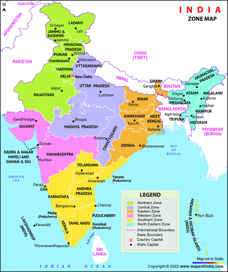
States in the Northern Zone:
- Jammu & Kashmir (UT)
- Ladakh (UT)
- Himachal Pradesh
- Punjab
- Haryana
- Delhi (UT)
- Rajasthan
Key Features:
- Geography: The region is home to the Himalayas in the north, the fertile plains of the Ganges, and the arid Thar desert in parts of Haryana and Punjab.
- Cultural Significance: Northern India has been the cradle of ancient civilizations like the Indus Valley Civilization and home to major religious sites for Hinduism, Sikhism, and Islam.
- Economic Role: Agriculture is the backbone of the region, with Punjab and Haryana known as the “Granary of India.” Industrial hubs like Noida and Gurugram are also located here.
2. North-Eastern Zone
The North-Eastern Zone is one of the most culturally diverse and geographically isolated regions of India, with distinct languages, cohorts, and customs. People know the region for its scenic beauty, biodiversity, and unique ethnic makeup.
States in the North-Eastern Zone:
- Assam
- Meghalaya
- Nagaland
- Manipur
- Mizoram
- Tripura
- Arunachal Pradesh
- Sikkim
Key Features:
- Geography: The northeastern states are characterized by their hilly terrain, forests, and rivers. The Brahmaputra River dominates Assam’s landscape, while the region is also part of the Eastern Himalayas.
- Cultural Significance: The region has a rich tribal culture, with each state home to various indigenous communities with distinct languages and traditions.
- Economic Role: Agriculture, particularly tea cultivation in Assam, and oil production are major economic activities. The region also holds significant strategic importance due to its proximity to international borders (China, Myanmar, Bangladesh, Bhutan).
3. Western Zone
The Western Zone of India is known for its vibrant culture, historical landmarks, and diverse geography, ranging from deserts to beaches. This zone is also one of the most industrialized regions of the country.
States in the Western Zone:
- Gujarat
- Maharashtra
- Goa
- Dadra & Nagar Haveli and Daman & Diu (UT)
Key Features:
- Geography: The zone includes, the Rann of Kutch in Gujarat, and the Western Ghats that run along the coast of Maharashtra and Goa.
- Cultural Significance: Western India is known for its colorful festivals, traditional dance forms like Garba, and historic forts.
- Economic Role: The region is industrially developed, with cities like Mumbai, India’s financial capital, and Ahmedabad in Gujarat being major economic hubs. Ports in Gujarat and Maharashtra contribute significantly to India’s trade.
4. Eastern Zone
The Eastern Zone of India is rich in natural resources and cultural heritage. It is known for its diverse ecosystems, including the Sundarbans, the world’s largest mangrove forest, and its rich history linked to India’s struggle for independence.
States in the Eastern Zone:
- Bihar
- West Bengal
- Odisha
- Jharkhand
Key Features:
- Geography: The zone includes the fertile Gangetic plains, dense forests, and coastal regions along the Bay of Bengal. The Sundarbans in West Bengal is a UNESCO World Heritage site.
- Cultural Significance: The region is famous for its contributions to Indian classical music, dance, and literature. West Bengal, in particular, is known for the Durga Puja festival and its rich artistic heritage.
- Economic Role: Coal mining in Jharkhand, iron and steel production in Odisha, and tea cultivation in West Bengal are key industries in the region. Bihar and Odisha are also significant agricultural producers.
5. Southern Zone
The Southern Zone of India is known for its distinct Dravidian culture, rich history, and linguistic diversity. The region is home to several of India’s largest and most advanced cities and is a hub for technology and education.
States in the Southern Zone:
- Andhra Pradesh
- Karnataka
- Kerala
- Tamil Nadu
- Telangana
- Puducherry (UT)
- Lakshadweep (UT)
- Andaman and Nicobar Islands (UT)
Key Features:
- Geography: The region has a diverse landscape, including the Western and Eastern Ghats, coastal plains, and the Deccan Plateau. Tourists highly regard Kerala’s backwaters and Karnataka’s hill stations as top destinations.
- Cultural Significance: People recognize South India for its classical music, dance forms like Bharatanatyam, and intricate temple architecture. The region is also a center for Hinduism and early Christian and Islamic influences.
- Economic Role: People consider the Southern Zone a major hub for IT and software services, and they refer to Bengaluru as India’s ‘Silicon Valley.’ It also has strong agricultural and manufacturing sectors.
6. Central Zone
The Central Zone includes states that lie at the heart of India, known for their dense forests, rich mineral resources, and significant tribal populations.
States in the Central Zone:
- Madhya Pradesh
- Chhattisgarh
- Uttarakhand
- Uttar Pradesh
Key Features:
- Geography: The forests and plateaus characterize this region, and a significant portion of India’s tiger population resides in Madhya Pradesh’s national parks. The Narmada and Tapi rivers flow through the region.
- Cultural Significance: Central India has a rich tribal culture, with numerous cohorts that have preserved their traditions and customs. The region is also home to several ancient temples and historic sites.
- Economic Role: The Central Zone is rich in natural resources like coal, iron, and bauxite, making it a major center for mining and mineral-based industries.
7. Union Territories Zone
The Union Territories (UTs) are regions governed directly by the Central Government of India. These areas, though smaller in size compared to states, have their own unique importance, often due to strategic, cultural, or economic factors.
The union territories of Andaman and Nicobar Islands and Lakshadweep are not members of any of the Zonal Councils. However, they are presently special invitees to the Southern Zonal Council.
Union Territories:
- Andaman and Nicobar Islands
- Chandigarh
- Lakshadweep
- Delhi
- Puducherry
- Dadra & Nagar Haveli and Daman & Diu
- Ladakh
- Jammu & Kashmir
Key Features:
- Strategic Importance: UTs like Andaman and Nicobar Islands and Lakshadweep are critical for India’s maritime security and influence in the Indian Ocean region.
- Cultural Significance: Delhi, as the capital of India, is a cultural, political, and historical hub. Chandigarh is known for its urban planning and architecture by Le Corbusier.
- Economic Role: UTs like Delhi and Puducherry are centers of tourism, trade, and governance, contributing significantly to the national economy.
Indian States Zone classification
| Zone | States/UTs | Headquarters |
|---|
| Northern Zone | Jammu & Kashmir (UT), Ladakh (UT), Himachal Pradesh, Punjab, Haryana, Delhi (UT), Rajasthan | New Delhi |
| North-Eastern Zone | Assam, Meghalaya, Nagaland, Manipur, Mizoram, Tripura, Arunachal Pradesh, Sikkim | Shillong |
| Western Zone | Gujarat, Maharashtra, Goa, Dadra & Nagar Haveli and Daman & Diu (UT) | Mumbai |
| Eastern Zone | Bihar, West Bengal, Odisha, Jharkhand | Kolkata |
| Southern Zone | Andhra Pradesh, Karnataka, Kerala, Tamil Nadu, Telangana, Puducherry (UT), Lakshadweep (UT), Andaman and Nicobar Islands(UT) | Chennai |
| Central Zone | Madhya Pradesh, Chhattisgarh, Uttarakhand, Uttar Pradesh | Prayagraj |
| Union Territories Zone | Andaman & Nicobar Islands, Chandigarh, Lakshadweep, Delhi (UT), Puducherry (UT), Dadra & Nagar Haveli and Daman & Diu (UT), Ladakh (UT), Jammu & Kashmir (UT) | Strategic importance (e.g., Andaman & Nicobar Islands for maritime security), tourism, trade, governance, cultural hubs like Delhi and Puducherry |
Conclusion
India’s zonal classification helps improve the administration, economic planning, and cultural understanding of the country. Each zone has its unique strengths and challenges, contributing to India’s diversity and its role as a growing global power. From the Himalayan landscapes in the north to the coastal beauty of the south, and from the deserts in the west to the lush forests in the east, the Indian States Zones collectively reflect the country’s immense diversity and complexity.
India’s regional diversity is not only geographical but also cultural, linguistic, and economic, making the zonal division essential for understanding the vast and dynamic nature of the nation.
Read Also
- Exploring the Rich Tapestry of Marathi Language and Literature
- Languages and Dialects of Madhya Pradesh
- Language Immersion Programs
- India’s UNESCO World Heritage Sites
- Co-operative Dairies in India
- PAN 2.0: Revolutionizing India’s Tax System
- States and Capitals of India – 2024
- Major Stadiums in India
- National Identity Card India
- Foundation Day of States in India
- Important Mountain Passes in India
- List of important gadgets for students

Physical Features of India Learn 50+ Geographical Features
50+ FEATURES TO LEARN: Solve the puzzle with river & desert shaped pieces, add the 3D mountains & plateaus to complete the map and get a play way experience of learning about the Physical Features of India
Frequently Asked Questions (FAQs)
India is commonly divided into six zones: North, South, East, West, Central, and Northeast.
Indian states are divided into zones to facilitate better administration, development planning, and resource management. It also helps in addressing regional issues more effectively.
Zonal divisions help in targeted economic planning and development, ensuring that the specific needs and strengths of each region are addressed. This can lead to more balanced and inclusive growth across the country.
While the zones themselves do not have direct political significance, they often influence regional politics, alliances, and policy-making at both the state and national levels.
Yes, Union Territories like Delhi, Ladakh, Puducherry, Andaman & Nicobar Islands, and others are categorized based on their geographical location or administrative importance.