


The Brahmaputra River, often referred to as the “Sorrow of Assam,” is a majestic waterway that flows through the northeastern states of India. It rises from the frozen depths of the Tibetan Himalayas, flows across China, India, and Bangladesh, and eventually joins the Ganges to create the biggest delta on Earth. The Brahmaputra has enormous geographical and cultural significance due to its route, yearly flooding patterns, and significant impact on the northeastern states of India. The Brahmaputra, a mighty river, shapes the lives of millions in its ever-changing course.
The Brahmaputra’s source is the Chemayungdung Glacier, which covers the slopes of the Himalayas about 60 miles (100 km) southeast of Lake Mapam in southwestern Tibet. The three headstreams that arise there are the Kubi, the Angsi, and the Chemayungdung. From its source, the river runs for nearly 700 miles (1,100 km) in a generally easterly direction between the Great Himalayas range to the south and the Kailas Range to the north. Throughout its upper course, the river is generally known as the Tsangpo (“Purifier”); it is also known by its Chinese name (Yarlung Zangbo) and by other local Tibetan names.
The upper reaches of the Brahmaputra River, known as the Yarlung Tsangpo from the Tibetan language, originates on the Angsi Glacier, near Mount Kailash, located on the northern side of the Himalayas in Burang County of Tibet. The source of the river was earlier thought to be on the Chemayungdung glacier, which covers the slopes of the Himalayas about 97 km (60 mi) southeast of Lake Manasarovar in southwestern Tibet.
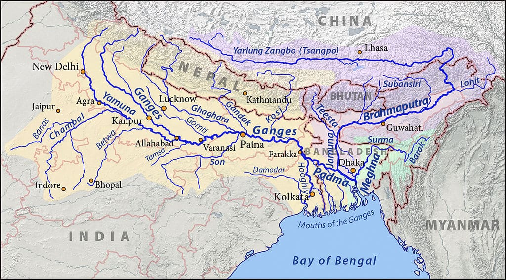
The Course of the Brahmaputra
- Total length: Approximately 2,900 km (1,800 miles), making it one of the longest rivers in Asia.
- Origin: It begins in the Angsi Glacier in the Himalayas of Tibet, where it’s known as the Yarlung Tsangpo. It begins in the Kailash Range near the Mansarovar Lake.
- Tibet: The river flows eastward across southern Tibet for about 1,125 km (699 miles).
- The Great Bend: Near Namcha Barwa, it makes a dramatic U-turn, known as the “Great Bend,” and cuts through the eastern Himalayan range.
- Arunachal Pradesh: The river enters India in Arunachal Pradesh, known as the Siang or Dihang.
- Assam: The Dibang and Lohit rivers join in the Assam Valley, officially becoming the Brahmaputra.
- Bangladesh: The river flows south into Bangladesh, where people call it the Jamuna before it merges with the Ganges to form the Padma River.
- Bay of Bengal: Finally, it empties into the Bay of Bengal.
Wide, braided channels and dynamic meandering characterize the river’s journey. In Assam, the Brahmaputra broadens significantly, sometimes stretching over 10 kilometers wide. This extensive width is due to the river’s high sediment load and the region’s flat topography. As it enters Bangladesh, the river splits into multiple distributaries before joining the Ganges and flowing into the Bay of Bengal.
The river originates from the Kailash ranges of the Himalayas at an elevation of 5300 M. After flowing through Tibet it enters India through Arunachal Pradesh and flows through Assam and Bangladesh before it joins the Bay of Bengal. The catchment area of Brahmaputra in Tibet is 2, 93,000 Sq.
Annual Flooding Patterns
The yearly floods caused by the Brahmaputra are well-known and both beneficial and detrimental to the area. The river’s catchment area has intense rainfall during the monsoon season, which runs from June to September. Heavy rainfall combined with snowmelt from the Himalayas causes the river to overflow its banks, leading to widespread inundation.
Intense monsoon rains characterize the annual flooding patterns of the Brahmaputra River. During this time, the river overflows its banks, inundating vast areas of Assam and neighboring states. These floods impacted more than 16 lakh lives, leading to displacement, loss of homes, and disrupted livelihoods. Despite the challenges, local communities adapt by building embankments and supporting each other.
Assam and the northeastern states experience flooding every year, which causes extensive inundation of villages, farmlands, and infrastructure. Because of the river’s dynamic character, its channels can change significantly, eroding land in some places and depositing fertile silt in others. Although this process improves soil fertility, it can have disastrous effects on the communities that live along the banks of the river.
These floods deposit nutrient-rich alluvial soil, benefiting agriculture by enhancing soil fertility. However, they also cause extensive damage, displacing communities, destroying homes and infrastructure, and posing health risks due to waterborne diseases. The river’s dynamic and shifting channels exacerbate the impact, making effective flood management and disaster preparedness essential for the regions, particularly in Assam and the northeastern states of India.
Impact on Lives in the Northeastern States
The Brahmaputra’s flooding had a profound impact on the lives of people in the northeastern states of India, particularly in Assam. While the floods bring fertile silt that replenishes agricultural lands, they also cause significant destruction.
- Agriculture: The floods deposit rich alluvial soil, which is crucial for agriculture, the mainstay of the region’s economy. Farmers depend on the nutrient-rich silt to grow crops like rice, tea, and jute. However, the unpredictability of the floods can destroy standing crops and delay planting seasons.
- Displacement and Loss: Annual floods displace thousands of people, submerge homes, and destroy property. Temporary shelters and relief camps become a reality for many during the monsoon season. Recurrent displacement disrupts the social fabric and economic stability of communities.
- Health and Sanitation: Flooding often leads to water contamination and outbreaks of waterborne diseases. Access to clean drinking water and sanitation facilities becomes challenging, exacerbating health risks for affected populations.
- Infrastructure Damage: Roads, bridges, and other critical infrastructure suffer extensive damage during floods. Repair and rebuilding efforts require substantial resources, straining the region’s development efforts.
- Biodiversity: The Brahmaputra basin is home to rich biodiversity, including the Kaziranga National Park, a UNESCO World Heritage site. Flooding is essential for maintaining the park’s ecosystem, supporting species like the one-horned rhinoceros. However, extreme floods can also pose threats to wildlife.
Adaptation and Mitigation Strategies
People are implementing various adaptation and mitigation strategies to cope with the challenges posed by the Brahmaputra floods.:
- Early Warning Systems: Improved meteorological and hydrological monitoring systems provide early warnings of impending floods, allowing for timely evacuations and preparations.
- Flood Management Infrastructure: Construction of embankments, levees, and reservoirs aims to control and mitigate the impact of floods. However, these structures require regular maintenance and monitoring.
- Disaster Preparedness: Community-based disaster preparedness programs educate and train residents on how to respond to floods, reducing vulnerability and enhancing resilience.
- Sustainable Land Management: Afforestation, soil conservation, and sustainable agriculture help reduce flood impact and enhance the environment’s capacity to absorb excess water.
- Policy and Governance: Effective water management policies and inter-state coordination are crucial for managing the Brahmaputra’s waters and addressing the needs of affected populations.
Conclusion
The Brahmaputra River, with its majestic course and annual flooding, is both a lifeline and a challenge for the northeastern states of India. Its waters sustain agriculture, nourish ecosystems, and shape the region’s culture and economy. The Brahmaputra’s dynamic nature and its devastating floods necessitate comprehensive and adaptive strategies to mitigate risks and enhance resilience. Understanding and managing the Brahmaputra’s mighty flow is essential for the sustainable development and well-being of the millions who depend on its waters.
Key Facts About the Brahmaputra River
- The Brahmaputra River is approximately 2,900 kilometers (1,800 miles) long.
- The Brahmaputra River originates from the Angsi Glacier in the Tibetan Himalayas, where it is known as the Yarlung Tsangpo River.
- It is the 9th largest river in the world by discharge and the 15th longest.
- The river flows through four countries: China, India, Bhutan (via its tributary Manas), and Bangladesh.
- Names: The river is known by different names in different regions:
- *. Yarlung Tsangpo in Tibet
- *. Siang or Dihang in Arunachal Pradesh
- *. Brahmaputra in Assam
- *. Jamuna in Bangladesh
- In Assam, the Brahmaputra is known for its wide and braided channels, often exceeding 10 kilometers in width in some places.
- The river drains an area of about 580,000 square kilometers (224,000 sq mi).
- Average discharge of about 19,800 cubic meters per second (700,000 cubic feet per second) at its mouth.
- The Yarlung Tsangpo Grand Canyon in Tibet, formed by the river, is the deepest canyon in the world.
- The Brahmaputra is prone to catastrophic flooding, with major floods occurring almost annually.
- The river is home to the endangered Ganges River Dolphin.
- The river is mentioned in ancient Hindu scriptures, including the Mahabharata.
- A dedicated government body, the Brahmaputra Board, was established in 1980 for the management of the river.
- It is considered sacred by Buddhists in Tibet but not among Muslims in Bangladesh.
TO LEARN MORE CLICK BELOW
- Sikkim Wins Best State Award for Environment Education
- Duckweed-Based Wastewater Treatment Systems
- Himalayan Glaciology: Study of Glaciers in the Indian Himalayas
- Agartala’s Flood Mitigation Project Honored at LBSNAA
- Agartala: A Model for Flood-Resilient Cities
- Mawlynnong: Asia’s Cleanest Village
- Sikkim’s Physical Features: A Himalayan Wonder
- The Timeless Purity of Ganga
- The Sacred Ganga: Lifeline of India

Frequently Asked Questions (FAQs)
The Brahmaputra River originates from the Angsi Glacier in the Tibetan Himalayas at an elevation of about 5,300 meters (17,400 feet). In Tibet, it is known as the Yarlung Tsangpo River.
The Brahmaputra River flows through three countries: China (where it is called the Yarlung Tsangpo), India, and Bangladesh (where it is known as the Jamuna before merging with the Ganges).
The Brahmaputra River is approximately 2,900 kilometers (1,800 miles) long.
Major tributaries of the Brahmaputra River include the Subansiri, Manas, and Teesta rivers, which significantly contribute to its flow and sediment load.
Heavy monsoon rains from June to September and snowmelt from the Himalayas cause the annual flooding of the Brahmaputra River, leading to the river swelling and overflowing its banks.
The river originates from the Kailash ranges of the Himalayas at an elevation of 5300 M. After flowing through Tibet it enters India through Arunachal Pradesh and flows through Assam and Bangladesh before it joins the Bay of Bengal. The catchment area of Brahmaputra in Tibet is 2, 93,000 Sq.
The Brahmaputra River originates near the Chemayungdung glacier near Mansarovar in Tibet. With an average width of 80 km, the Brahmaputra, known as the Yarlung Tsangpo in Tibet, enters India through Arunachal Pradesh. Then it flows through Assam and Bangladesh before joining the Bay of Bengal.
Your article helped me a lot, is there any more related content? Thanks!