


Nestled in northernmost India, Kashmir is a region often celebrated for its stunning landscapes, lush valleys, and majestic mountains. Known as “Paradise on Earth,” the region’s physical features are as diverse as they are breathtaking, shaped by millennia of geological processes. The Physical Features of Kashmir, including its snow-capped mountains and serene lakes, contribute significantly to its breathtaking beauty. Let’s look at the physical characteristics that make Kashmir a geographical marvel.
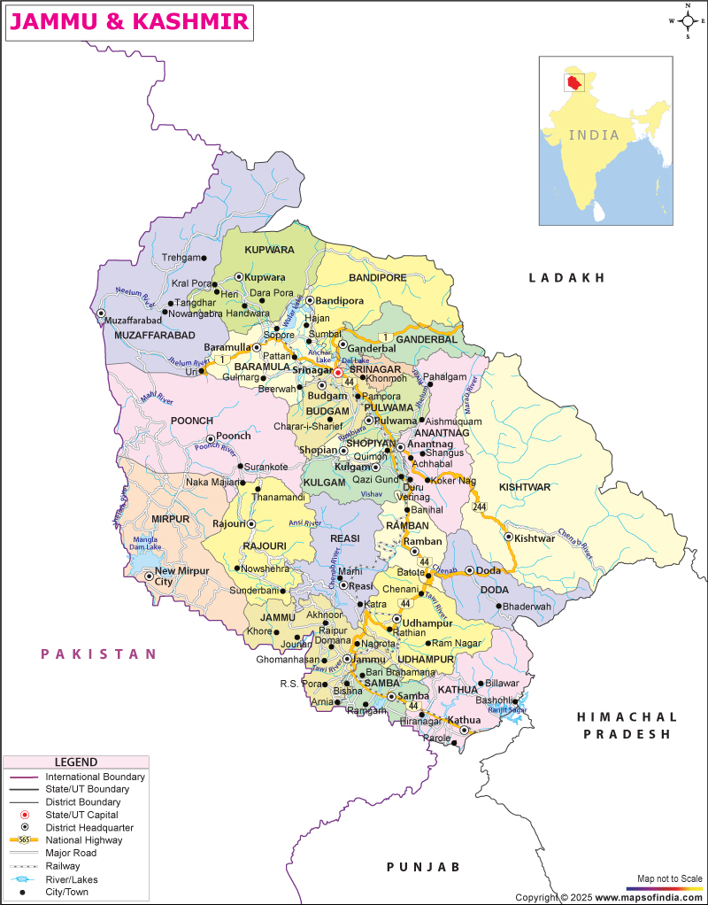
The total area of Jammu and Kashmir is 101387 square kilometers. It is located between longitudes 72°31′ and 80°20′ East and latitudes 32°17′ and 37°05′ North. The Kashmir Valley and Jammu, two geographical regions, separate it. The inner Himalayan mountain ranges, the Karakoram, and the Pir Panjal encompass the higher regions. The Tawi, Jhelum, and Chenab are the three major river systems in the UT.
1. The Majestic Himalayas
Kashmir is predominantly mountainous, with the Great Himalayas, which serve as a natural barrier between the Indian subcontinent and Central Asia, and the Pir Panjal Range forming its backbone. These ranges are home to some of the highest peaks in the world, including Nanga Parbat and K2. This serves as a natural barrier between the Indian subcontinent and Central Asia. The Pir Panjal Range to the southwest and the main Himalayan Range to the northeast dominate the region. The mountains are a visual threat and play a crucial role in the region’s climate and hydrology.
- Pir Panjal Range: The southwestern boundary of the Kashmir Valley is formed by this range, which features peaks reaching elevations of over 4,000 meters (13,000 feet). Ancient rocks, including granites and gneisses, primarily compose the range. It plays a critical role in shaping the valley’s climate by blocking cold winds from the north.
- Great Himalayan Range: To the northeast, the Great Himalayan Range towers over the valley with some of the world’s highest peaks. The range is home to Nun Kun, one of the highest peaks in the region at 7,135 meters (23,409 feet). Snow covers the mountains year-round, and they are the source of many of the rivers that flow through Kashmir.
2. The Kashmir Valley
The elliptical depression known as the Kashmir Valley, or the Vale of Kashmir, nestles between the Pir Panjal and Zanskar ranges. The valley spans approximately 135 kilometers in length and 32 kilometers in width, creating a lush, fertile landscape.
- It lies at an altitude of about 1,600 meters(5,200 feet) above sea level.
- Formed by tectonic activity and previously covered by an ancient lake called Satisar.
- Surrounded by mountains, the valley enjoys a moderate climate with warm summers and snowy winters.
- The fertile alluvial soil and moderate temperatures make this valley ideal for agriculture, especially saffron, apples, and walnuts.
- Rich in natural vegetation — includes chinars, deodar trees, apple orchards, and saffron fields. Home to wildlife such as hangul (Kashmiri stag), Himalayan black bear, and snow leopard.
3. Lakes and Water Bodies
Dal Lake (Srinagar):
- Nicknamed the “Jewel in the Crown of Kashmir.”
- Famous for houseboats, shikaras, and floating gardens.
- Divided into four basins: Gagribal, Lokut Dal, Bod Dal, and Nagin Lake.
- Surrounded by Mughal gardens, Zabarwan hills, and vibrant local markets on water.
Wular Lake (Bandipora):
- One of the largest freshwater lakes in Asia.
- Fed by the Jhelum River, crucial for flood control and biodiversity.
- Home to a wide variety of birds, fish, and aquatic plants.
- Acts as a natural reservoir and supports the local fishing industry.
Manasbal Lake (Ganderbal):
- Often called the “Supreme Gem of all Kashmir Lakes.”
- The deepest lake in the Kashmir Valley, ideal for boating and birdwatching.
- Surrounded by lotus plantations and villages with ancient Mughal-era ruins.
Nigeen Lake (Srinagar):
- A calmer extension of Dal Lake, known for its cleaner and quieter environment.
- Popular for swimming, sailing, and houseboat stays.
- Lined with willow and poplar trees, offering scenic beauty.
Gangbal Lake (at Mount Harmukh):
- A high-altitude alpine lake, also known as Harmuk Ganga.
- Considered sacred by Hindus, part of the Great Lakes Trek.
- Fed by glaciers and surrounded by meadows and rugged mountains.
Tarsar and Marsar Lakes (Anantnag District):
- Twin alpine lakes are located in the Aru Valley region.
- Popular for trekking and camping, offering stunning reflections of snow-covered peaks.
- Surrounded by lush meadows and pine forests.
Sheshnag Lake (Near Pahalgam):
- A Glacial lake situated on the way to Amarnath Cave.
- Believed to be the abode of Sheshnag, the mythical serpent.
- Emerald green waters and stunning alpine landscape make it spiritually and scenically important.
Krishansar & Vishansar Lakes (Sonmarg Region):
- Located near Nichnai Pass, popular among trekkers.
- These lakes remain frozen in winter and bloom with wildflowers in summer.
- Provide water for rivers and are ideal for high-altitude camping.
4. The Zanskar Range
The Zanskar Range lies to the northeast of the Kashmir Valley and forms the boundary between Kashmir and Ladakh. This range is rugged and sparsely vegetated, with some peaks rising above 6,000 meters (19,685 feet). The region is known for its harsh climate and challenging terrain, attracting adventure seekers and trekkers.
- Location & Geography:
- The Zanskar Range is a part of the Tethys Himalayas (also called the Trans-Himalayas).
- Lies north of the Great Himalayan Range, mostly in Ladakh and parts of Jammu & Kashmir.
- Forms a natural divide between Zanskar Valley and the Indus Valley.
- Elevation & Peaks:
- Average elevation ranges from 6,000 to 7,000 meters (19,685 to 22,965 feet).
- Notable peaks include Nun (7,135 m) and Kun (7,077 m) — the highest peaks in the Indian state of Jammu and Kashmir.
- Several unclimbed and remote peaks still exist in this rugged range.
- Formation & Geology:
- Formed by the collision of the Indian and Eurasian plates during the Himalayan orogeny.
- Composed mainly of limestone, shale, and metamorphic rocks, rich in fossils from the Tethys Sea.
- Climate:
- Harsh alpine and arid climate, with extremely cold winters and short summers.
- Most of the region remains snow-covered for over 6 months.
- Zanskar River & Chadar Trek:
- The Zanskar River carves deep gorges through the range and joins the Indus River.
- In winter, the river freezes, creating the famous Chadar Trek, where trekkers walk on the frozen river.
- Cultural & Religious Significance:
- Inhabited by Tibetan-Buddhist communities in isolated valleys and monasteries.
- Ancient monasteries like Phugtal, Karsha, and Stongdey are perched on cliffs in the Zanskar Range.
- Adventure Tourism & Trekking:
- Offers some of India’s most challenging treks, ice-climbing routes, and expeditions.
- Popular treks: Padum to Lamayuru, Chadar Trek, and Darcha to Padum.
- Remote, pristine, and less commercialized compared to other Himalayan trekking routes.
- Accessibility:
- Accessible via Kargil and Leh, but roads are often closed in winter due to heavy snowfall.
- Air travel to Leh, followed by road journeys, is the most common approach in summer.
- Ecological Importance:
- High-altitude ecosystem with rare wildlife like snow leopards, ibex, marmots, and Himalayan blue sheep.
- Sensitive environment facing challenges due to climate change and glacier melt.
- Strategic Significance:
- Located near the India-China border, hence of military and geopolitical importance.
- Serves as a crucial barrier and buffer zone in the northern Himalayan region.
5. Flora and Fauna
Kashmir’s varied topography and climate support a rich diversity of flora and fauna. Dense forests of pine, deodar, and fir cover the lower slopes of the mountains, while alpine meadows characterize the higher elevations.
There are roughly 3054 species of plants in the Himalayan Kashmir. These figures represent only the angiosperms, gymnosperms, and pteridophytes. People widely recognize the therapeutic qualities of the plants found in the western Himalayas. This area serves as a storage facility for aromatic and medicinal plants used in the perfume and pharmaceutical industries. 55 significant species of aromatic and therapeutic plants are on the list. The temperate, cold, dry regions of J&K are home to eleven medicinal plants. Numerous therapeutic plants naturally flourish in alpine and temperate regions.
- Wildlife: The region is home to several species of wildlife, including the Kashmir stag (Hangul), snow leopard, brown bear, and various species of pheasants and birds. The Dachigam National Park, located near Srinagar, is a protected area that conserves the region’s unique biodiversity.
- Vegetation: Kashmir’s vegetation ranges from temperate forests in the valleys to alpine meadows at higher altitudes. The region is also famous for its saffron fields, which produce some of the finest saffron in the world.
6. Glaciers and Rivers
❄️ Glaciers of Kashmir
- Kolhai Glacier (Anantnag District):
- The largest glacier in the Kashmir Valley.
- Source of the Lidder River, a tributary of the Jhelum.
- Rapidly retreating due to climate change, and is monitored closely by researchers.
- Located near the Kolhai Peak (5,425 m), a popular trekking region.
- Thajiwas Glacier (Sonamarg):
- Easily accessible and popular among tourists.
- Located at the foot of Sonamarg, ideal for sledding and short treks.
- Seasonal and melts into smaller streams feeding the Sind River.
- Machoi Glacier (Zojila Pass region):
- Drang-Drung Glacier (Zanskar Region):
- One of the largest glaciers in the Ladakh-Kashmir Himalayas.
- Source of the Stod River, a major tributary of the Zanskar River.
- Viewable from Pensi La pass, famous among trekkers and bikers.
- Shafat Glacier (Suru Valley, Kargil):
- Located between Nun and Kun peaks.
- Important for local glacial melt-based irrigation systems.
- Supports the Suru River, which flows into the Indus.
🌊 Major Rivers of Kashmir
- Jhelum River (Vitasta):
- Lifeline of the Kashmir Valley, originating from Verinag Spring in Anantnag.
- Flows through Srinagar and Wular Lake, eventually entering Pakistan.
- Vital for irrigation, drinking water, and hydroelectricity.
- Associated with ancient Kashmiri history and Hindu mythology.
- Chenab River:
- Originates from the Baralacha Pass in Himachal Pradesh.
- Flows through the Jammu region before entering Pakistan.
- Known for steep gorges and high hydroelectric potential (Baglihar Dam, Salal Dam).
- Indus River:
- Enters India via Ladakh, flowing through Leh, Kargil, and into Pakistan.
- Major trans-Himalayan river; supports glacial agriculture and military outposts.
- Crucial for India’s share under the Indus Waters Treaty.
- Lidder River:
- Originates from Kolhai Glacier near Pahalgam.
- Popular for trout fishing and white-water rafting.
- Feeds the Jhelum and supports Anantnag district’s agriculture.
- Sind River:
- Originates from the Machoi Glacier near Zojila.
- Passes through Sonamarg and Ganderbal, merging with the Jhelum.
- Essential for hydroelectricity and the drinking water supply to Srinagar.
- Zanskar River:
- Originates from Drang-Drung Glacier, flows through deep gorges.
- Joins the Indus near Nimmu, Leh.
- Famous for the Chadar Trek (frozen river walk in winter).
Plateaus and Highlands of Kashmir
📍 1. The Ladakh Plateau
- Location: Lies in the eastern part of Jammu & Kashmir and the Union Territory of Ladakh.
- Elevation: One of the highest inhabited plateaus in the world, with altitudes between 3,000–5,000 meters.
- Terrain: Cold desert region with barren, windswept plateaus, rugged mountains, and sparse vegetation.
- Climate: Extremely arid, with minimal rainfall and sub-zero temperatures during winter.
- Significance:
- Home to ancient Buddhist culture and monasteries (Hemis, Thiksey, Alchi).
- Host towns like Leh and Kargil.
- Offers unique high-altitude ecosystems and is part of the Trans-Himalayan biodiversity zone.
- Strategic importance due to proximity to the India-China border.
📍 2. Zanskar Plateau (Zanskar Highlands)
- Location: Lies west of the Ladakh Plateau, separated by the Zanskar Range.
- Elevation: Around 3,700–4,200 meters.
- Landscape: Deep gorges, frozen rivers, and glacial valleys.
- Cultural Highlights:
- Inhabited by Zanskari people, followers of Tibetan Buddhism.
- Known for remote monasteries like Phuktal and Karsha.
- Adventure: Base for popular treks like the Chadar Trek and Padum to Lamayuru.
📍 3. Karewa Plateaus (Marlas)
- Location: Found mainly in the Kashmir Valley, especially near Pulwama, Budgam, and Anantnag.
- Formation: Composed of lacustrine (lake) deposits of clay, silt, and sand, uplifted by tectonic forces.
- Importance:
- Extremely fertile, ideal for the cultivation of saffron, almonds, and orchards.
- Rich in fossils, offering insights into prehistoric flora and fauna.
- Serve as natural terraces and residential zones in Kashmir.
- Unique Feature: Karewas are specific to the Kashmir Valley, making them a geo-heritage feature.
📍 4. Dras and Kargil Highlands
- Location: Western part of Ladakh near the LoC (Line of Control).
- Elevation: ~2,800 to 3,300 meters.
- Climate: One of the coldest inhabited places on Earth, especially Dras, which records temperatures as low as −45°C.
- Strategic Relevance: Site of the Kargil War (1999) and has a significant military deployment.
- Geographical Traits:
- Rugged terrain, thin vegetation.
- Rivers like the Dras River cut through the valleys and merge into the Suru and Indus.
📍 5. Tso Moriri and Pangong Tso Basins
- Location: Southeastern Ladakh region, on the Tibetan Plateau.
- Geography: High-altitude endorheic lake basins surrounded by plateaus.
- Ecology:
- Habitat for migratory birds, including black-necked cranes.
- Designated as wetlands of international importance under the Ramsar Convention.
- Tourism: Popular for their scenic beauty and tranquility.
Soils and Vegetation
| Aspect | Details |
|---|
| Alluvial Soils | Found in the Kashmir Valley, fertile, supports rice, maize, fruits, and vegetables. |
| Karewa Soils | Uplifted lake deposits, located on Karewa plateaus, are ideal for saffron, apples, and almonds. |
| Mountain Soils | Found in hilly forest regions, coarse texture, limited cultivation, supports coniferous forests. |
| Glacial Soils | High-altitude areas (Ladakh, Zanskar), poor fertility, support tundra vegetation. |
| Temperate Forests | Conifers (deodar, fir, pine); deciduous trees (maple, walnut); found in mid-altitude zones. |
| Alpine Meadows | Above 3,000 m, wildflowers, herbs; used for summer grazing by nomads. |
| Wetland Vegetation | Found near lakes (Dal, Wular), includes lotus, reeds; ecologically vital for birds and water balance. |
| Scrub Vegetation | Found in Ladakh and arid zones; includes thorny bushes, drought-resistant grasslands. |
Climate
| Climate Zone | Location | Features |
|---|
| Temperate Climate | Kashmir Valley | Cold winters, pleasant summers; snowfall in winter; rainfall from western disturbances. |
| Alpine Climate | Higher altitudes (Gulmarg, Pahalgam) | Cool summers, long snow-covered winters; supports alpine flora. |
| Cold Desert Climate | Ladakh, Zanskar | Extreme cold, arid, low precipitation; large temperature variations. |
| Sub-tropical Pockets | Foothills and southern fringes | Moderate summers, more humidity; short, mild winters. |
Conclusion
Kashmir’s physical features are a testament to the region’s natural beauty and geological significance. From the towering peaks of the Himalayas to the serene waters of its lakes and rivers, Kashmir’s landscape is a diverse and vibrant mosaic that continues to captivate the imagination of travelers, geographers, and nature lovers alike. Whether you seek adventure, tranquility, or a deeper connection with nature, Kashmir offers a unique and unforgettable experience.
Also Read
- Physical Features of Kashmir
- Dal Lake, Kashmir
- Major Lakes in India
- Important facts about India
- Top Tourist Places in Kashmir
- India’s States and UTs: A Colorful Tapestry of Nicknames
- Stargazing in India: Top Places to See the Milky Way
- 10 Most Breathtaking Natural Wonders in the World
- Pune Couple’s Heroic Act: Oxygen Plant for Siachen Soldiers
- States and Capitals of India – 2024
- Important Mountain Passes in India
- India’s International Borders
- India’s UNESCO World Heritage Sites
- Himalayan Glaciology: Study of Glaciers in the Indian Himalayas
- Coastal Landscapes of Indian States and the Nation
- Chenab River Bridge: World’s Highest Railway Arch Bridge in India
Important Facts About the Physical Features of Kashmir
- Mountain Ranges: Kashmir is predominantly mountainous, with the Great Himalayas and the Pir Panjal Range being the most significant ranges. These ranges include some of the highest peaks in the world, such as Nanga Parbat and K2.
- Vale of Kashmir: This lush, fertile valley is situated between the Great Himalayas and the Pir Panjal Range. It is known for its picturesque landscapes, including meadows, forests, and rivers, with the Jhelum River flowing through it.
- Rivers: The major rivers in Kashmir include the Jhelum, Indus, Chenab, and Ravi. The Jhelum River is particularly significant as it originates from the Verinag Spring and flows through the Vale of Kashmir.
- Lakes: Kashmir is home to several beautiful lakes, including Dal Lake, Wular Lake, and Manasbal Lake.
- Climate: The climate in Kashmir varies with altitude. The lower regions experience a subtropical climate, while the higher altitudes have an alpine climate. This variation supports a diverse range of vegetation.
- Vegetation: Kashmir’s vegetation ranges from dense coniferous forests in the mountains to deciduous forests and alpine meadows in the valleys. The region is also known for its orchards, producing fruits like apples, cherries, and walnuts.
- Ladakh Plateau: The Ladakh Plateau, located to the east of Kashmir, is a high-altitude desert that people know for its stark beauty and unique culture. It is characterized by its rugged terrain and extreme climate.
- Zanskar Valley: Known for its rugged terrain and remote location, the Zanskar Valley attracts adventure enthusiasts and trekkers due to its challenging landscapes and natural beauty.
- Geographical Zones: Five zones divide the physiography of Jammu and Kashmir: the plains, the foothills, the Pir Panjal Range, the Vale of Kashmir, and the Great Himalayas.

Frequently Asked Questions (FAQs)
Kashmir is primarily mountainous, with the Great Himalayas and the Pir Panjal Range being the most prominent mountain ranges. These ranges include some of the highest peaks in the world, such as Nanga Parbat and K2.
The Vale of Kashmir is a lush, fertile valley situated between the Great Himalayas and the Pir Panjal Range. People know it for its picturesque landscapes, including meadows, forests, and rivers, with the Jhelum River flowing through it.
The major rivers in Kashmir include the Jhelum, Indus, Chenab, and Ravi. The Jhelum River is particularly significant as it originates from the Verinag Spring and flows through the Vale of Kashmir.
Kashmir is home to several beautiful lakes, including Dal Lake, Wular Lake, and Manasbal Lake. These lakes are popular tourist attractions and add to the region’s scenic beauty.
Kashmir’s vegetation ranges from dense mountain coniferous forests to deciduous forests and alpine meadows in the valleys. People also know the region for its orchards, which produce fruits like apples, cherries, and walnuts.
Mountain passes like Zoji La and Banihal Pass are crucial for connecting Kashmir with the rest of India and neighboring regions like Ladakh. People rely on these passes for transportation, trade, and military movement, although they often find them snow-covered and challenging to traverse in winter.
Yes, Kashmir is home to several glaciers, which are crucial to the region’s water supply. Some of the prominent glaciers include the Kolahoi Glacier and the Sheshnag Glacier.